The danger of avalanches is low. Be careful in fresh snowdrift accumulations!
Snowpack is mostly stable. In some places in the high alpine regions, especially on fresh snowdrift accumulations of blown snow, a small, clustered Avalanche can be triggered under higher loads.
Snowpack
dp.4: cold following warm / warm following cold
There is little snow, and the peaks and ridges are in some places blown bare. The Sunny slopes below about 2000 m are also dry. Higher up, there is some new snow on old snow.
A crust has formed on the surface of the snowpack, which supports the weight of a pedestrian. In the high alpine regions, weak layers may be present in the old snow cover.
Up to 20 cm of dry snow will fall on such a surface on Wednesday. Snow will fall with a stronger NE wind building small drifts.
Tendency
Thursday will be cloudy and foggy with moderate NE winds. On Friday, the wind will be even lighter and it will clear up. The danger of avalanches will remain similar.
Danger level
2000m
Avalanche Problem
Persistent weak layer
2000m
Wind slab
Treeline
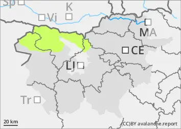
The danger of avalanches is low. Be careful in fresh snowdrift accumulations!
Snowpack is mostly stable. In some places in the high alpine regions, especially on fresh drifts of blown snow, a small, clustered avalanche can be triggered under higher loads.
Snowpack
dp.4: cold following warm / warm following cold
There is little snow, and the peaks and ridges are in some places blown bare. The Sunny slope below about 2000 m is also dry. Higher up, there is some new snow on old snow.
A crust has formed on the surface of the snowpack, which supports the weight of a pedestrian. In the high alpine regions, weak layers may be present in the old snow cover.
Up to 10 cm of dry snow will fall on such a surface on Wednesday. Snow will fall with a stronger NE wind building up small drifts.
Tendency
Thursday will be cloudy and foggy with moderate NE winds. On Friday, the wind will be even lighter and it will clear up. The danger of Avalanche will remain similar.
Danger level
treeline
Avalanche Problem
Wind slab
Treeline
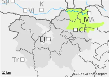
Almost half a metre of New fallen snow on Pohorje - be careful on steep meadows!
New fallen snow may spontaneously fall in small creeping patches on the steepest meadows. Snowdrift accumulations caused by increased NE winds in meadows will be vulnerable to additional load - possible triggering of a small kložast avalanche.
Snowpack
dp.6: cold, loose snow and wind
Up to 40 cm of New fallen snow will fall on land and snowdrift accumulations will form due to stronger NE winds.
Tendency
Thursday will be cloudy and foggy, with light snow and moderate NE winds. On Friday there will be less wind. The danger of avalanches will remain similar.