Caution urged on steep, shady slopes. Fresh snowdrifts will be generated during the daytime.
During the course of the day, mostly small-sized trigger-sensitive snowdrifts will accumulate. Older snowdrift masses can still be triggered, particularly on shady slopes. They have now been blanketed by fresh snowfall, making them difficult to recognize. Small-to-medium sized slab triggerings are possible by winter sports enthusiasts. In addition, slab avalanches can be unleashed in parts of the old snowpack by large additional loading. Caution urged on high-altitude very steep shady slopes. Particularly in zones with rain impact, increasingly frequent small-sized glide-snow avalanches are possible.
Snowpack
Due to increasing winds, loosely-packed snow will be transported at high altitudes and, from place to place some snowdrifts will accumulate, mostly small-sized. Particularly in high-altitude ridgeline terrain, snowdrift accumulations frequently lie deposited on top of surface hoar. With ascending altitude, the small-sized older snowdrifts are still prone to triggering. At high altitudes, particularly on shady slopes, faceted intermediate layers occur inside the snowpack, these can often be triggered. On smooth, steep slopes, isolated small-sized glide-snow avalanches have been reported.
Tendency
On Sunday afternoon and on Monday, avalanche danger could increase somewhat due to some fresh fallen snow and strong winds. On Monday, mild temperatures are expected.
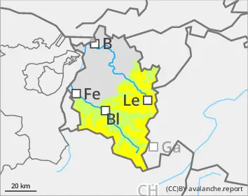
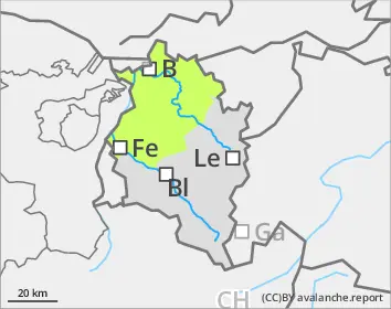
Danger level
treeline
Avalanche Problem
Wind slab
Treeline
Gliding snow
Only small amounts of fresh snow, low avalanche danger.
Avalanche danger is low. During the course of the day, mostly small-sized trigger-sensitive snowdrifts will accumulate above the timberline. Older snowdrift accumulations can still be triggered, particularly on shady slopes at high altitudes. Due to shallow snow depths, avalanches will remain small. Apart from being buried in snow masses, the risks of being swept along and forced to fall also require caution. Particularly in zones with rain impact, increasingly frequent small-sized glide-snow avalanches will again be possible.
Snowpack
Due to increasing winds, loosely-packed snow will be transported at high altitudes and, from place to place some snowdrifts will accumulate, mostly small-sized. Particularly in high-altitude ridgeline terrain, snowdrift accumulations frequently lie deposited on top of surface hoar. With ascending altitude, the small-sized older snowdrifts are still prone to triggering. At high altitudes, particularly on shady slopes, faceted intermediate layers occur inside the snowpack, these can often be triggered. On smooth, steep slopes, isolated small-sized glide-snow avalanches have been reported.
Tendency
On Sunday afternoon and on Monday, avalanche danger could increase somewhat due to some fresh fallen snow and strong winds. On Monday, mild temperatures are expected.