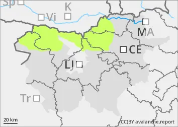
Danger level
 | treeline |
|  |
|  |

![]()
Above the tree line, weak layers may be present in the snow cover.
In a few places, a small to medium-sized avalanche can be triggered above the tree line under higher loads. Greater caution is needed, especially in shaded areas where weak layers may be present in the snow cover and in places with blowing snow. This is particularly true for concave landforms such as ravines and gullies.
Snowpack
dp.4: cold following warm / warm following cold
In recent days, the snow cover has been colliding, which could weaken the coherence of the snow cover in some areas, particularly on arid slopes. In sloping areas, the snow cover has started to transform more rapidly as the weather has warmed up, forming a crust. Snow is relatively scarce in the mountains. Due to the past influence of wind, the height of the snow cover is uneven and the surface of the snow cover has been reshaped. A few centimetres of light snow have fallen above an altitude of about 1500 m.
Tendency
There will be light to moderate snow in the evening and overnight on Friday, but the amount of new snow is not expected to be significant. Between 5 and 15 cm of new snow is expected. The risk of avalanches is unlikely to increase.