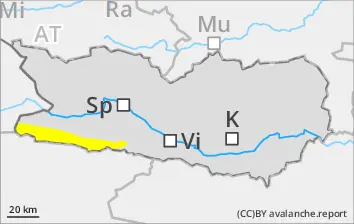
Wet-snow avalanches can in isolated cases be triggered by one winter sports enthusiast and grow to medium size. These avalanche prone locations are located particularly on W/N/E-facing slopes. Rainfall is anticipated in the afternoon, thereby the likelihood of triggerings will increase.
Snowpack
dp.10: springtime scenario
Weather conditions have led to the snowpack becoming thoroughly wet, forfeiting firmness of the snowpack. Many wet-snow avalanches have already released, many starting zones have completely discharged, the snowpack is thoroughly wet. Nocturnal outgoing longwave radiation is severely reduced, the snowpack hardly freezes, then soften rapidly in the morning hours. On steep sunny slopes below 1700m there is hardly any snow on the ground.
Tendency
Gradually receding avalanche danger
Danger level
Avalanche Problem
Wet snow
Beware wet snow. Isolated danger zones.
Naturally triggered wet-snow avalanches can be triggered esp. by large additional loading, most releases are small. Danger zones occur on W/N/E-facing slopes. Some rainfall is expected, which will then increase the likelihood of triggerings somewhat.
Snowpack
dp.10: springtime scenario
Weather conditions have led to the snowpack becoming thoroughly wet. Many wet-snow avalanches have already released, many starting zones have completely discharged. Nocturnal outgoing longwave radiation hardly exists. The snowpack surface can barely freeze and softens rapidly. On steep sunny slopes and below 1800m there is hardly any snow on the ground.
Tendency
No significant change expected
Danger level
2800m
Avalanche Problem
Wet snow
2800m
Wind slab
2800m
Beware wet-snow and snowdrifts in high-alpine terrain
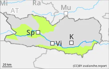
Wet-snow avalanches can in isolated cases be triggered by one winter sports enthusiast and grow to medium size. These avalanche prone locations are located particularly on W/N/E-facing slopes below 2800m. Rainfall is anticipated in the afternoon, thereby the likelihood of triggerings will increase. Fresh snowdrift accumulations can be triggered by one sole skier on very steep shady slopes above 2800m. Such danger zones occur esp. in ridgeline terrain, in gullies and in bowls.
Snowpack
dp.10: springtime scenario dp.6: cold, loose snow and wind
Weather conditions below 2800m have led to the snowpack becoming thoroughly wet, forfeiting firmness of the snowpack. Many wet-snow avalanches have already released, many starting zones have completely discharged, the snowpack is thoroughly wet. Due to often strong-velocity southerly winds, snowdrift accumulations have been generated. Weather will gradually stabilize these drifts. Nocturnal outgoing longwave radiation is severely reduced, the snowpack hardly freezes, then soften rapidly in the morning hours. On steep sunny slopes below 1900m there is hardly any snow on the ground.