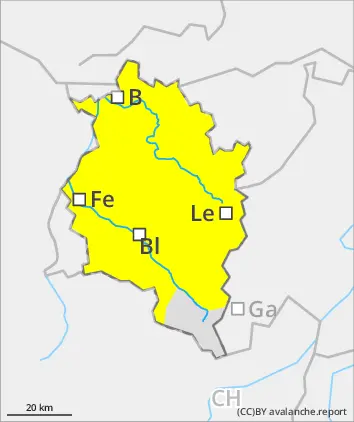
Following a mild night with overcast skies and reduced outgoing radiation, moderate danger prevails. Naturally triggered wet-snow and glide-snow avalanches can be expected, reaching medium size in high-altitude starting zones. Wet-snow avalanches can be triggered by persons in steep terrain. Due to rainfall, danger below 2400m could rise somewhat. Fresh snowdrifts require attentiveness in very high ridgeline terrain. In addition, the old snowpack can be triggered by large additional loading in extremely steep terrain. Apart from the danger of being buried in snow masses, the risks of being swept along and forced to take a fall require adequate caution.
Snowpack
The snowpack can’t consolidate well in the warm, cloudy nights, esp. on E/S/W-facing slopes up to high-alpine zones and on shady slopes below 2200m. The air is becoming moister, the old snowpack is thoroughly wet up to high altitudes. Due to rainfall below 2400m the snowpack is being additionally weakened. Brisk foehn winds are generating mostly small snowdrift accumulations in high ridgeline terrain. In shady wind-protected zones the uppermost layers are often soft. At lower altitudes there is very little snow on the ground.
Tendency
On Monday afternoon, short rain showers, snowfall level at 2600m, are possible. Danger of wet-snow and glide-snow avalanches persists.
Danger level
2500m
Avalanche Problem
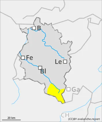
Persistent weak layer
2500m
Wet snow
Danger of wet avalanches even in the morning. Caution on very steep shady slopes in high-alpine zones.
Following a mild night with overcast skies and reduced outgoing radiation, moderate danger prevails. Naturally triggered wet-snow and glide-snow avalanches can be expected, reaching medium size in high-altitude starting zones. Wet-snow avalanches can be triggered by persons in steep terrain. Due to rainfall, danger below 2400m could rise somewhat. Fresh snowdrifts require attentiveness in very high ridgeline terrain. In addition, the old snowpack can be triggered by large additional loading in extremely steep terrain. Backcountry tours demand a cautious route selection. At high altitudes, fresh snowdrifts require attentiveness.
Snowpack
The snowpack can’t consolidate well in the warm, cloudy nights, esp. on E/S/W-facing slopes up to high-alpine zones and on shady slopes below 2200m. The air is becoming moister, the old snowpack is thoroughly wet up to high altitudes. Due to rainfall below 2400m the snowpack is being additionally weakened. Brisk foehn winds are generating mostly small snowdrift accumulations in high ridgeline terrain. In shady wind-protected zones the uppermost layers are often soft.
Tendency
On Monday afternoon, short rain showers, snowfall level at 2600m, are possible. Danger of wet-snow and glide-snow avalanches persists.