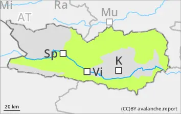
Rapidly rising danger of wet-snow avalanches. Beware persistent weak layers.
Due to solar radiation and daytime warmth, increasingly frequent wet-snow avalanches can be expected, including medium-sized releases, on very steep E/S/W-facing slopes, esp. below 2700m. Morning: acute danger of falls on the hardened crust on steep dlopes. Weak layers in the uppermost part of the snowpack can in isolated cases be triggered by one sole skier, danger zones occur esp. on steep N/W/E-facing slopes above 2400m. Isolated danger zones also occur on steep south-facing slopes above 2600m. Isolated avalanches can fracture down to more deeply embedded layers of the snowpack and grow to medium size.
Snowpack
dp.10: springtime scenario dp.1: deep persistent weak layer
Inside the old snowpack on N/W/E-facing slopes there are faceted, expansively metamorphosed weak layers, esp. abov 2400m. Clear skies over far-reaching areas: the surface freeze enough so that it can bear loads. Sunshine and warmth moisten the snowpack during the daytime, esp. on very steep E/S/W-facing slopes including at high altitudes, swiftly softening the snowpack which becomes thoroughly wet at low and intermediate altitudes. Below 1700m there is hardly any snow on the ground.
Tendency
Little change in avalanche danger levels anticipated
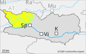
BEFORE NOON Danger level
2100m
Avalanche Problem
Persistent weak layer
2100m
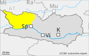
AFTERNOON Danger level
Avalanche Problem
Wet snow
Persistent weak layer
2100m
Beware persistent weak layers. Rising daytime danger of wet-snow avalanches.
Due to solar radiation and daytime warmth, increasingly frequent wet-snow avalanches can be expected, including medium-sized releases, on very steep E/S/W-facing slopes, esp. below 2700m. Morning: acute danger of falls on the hardened crust on steep dlopes. Weak layers in the uppermost part of the snowpack can in isolated cases be triggered by one sole skier, danger zones occur esp. on steep N/W/E-facing slopes above 2400m. Isolated danger zones also occur on steep south-facing slopes above 2600m. Isolated avalanches can fracture down to more deeply embedded layers of the snowpack and grow to medium size.
Snowpack
dp.10: springtime scenario dp.1: deep persistent weak layer
Inside the old snowpack on N/W/E-facing slopes there are faceted, expansively metamorphosed weak layers, esp. abov 2100m. Clear skies over far-reaching areas: due to low temperatures and low air moisture, surface crusts will form. Sunshine and warmth will moisten the snowpack during the daytime. The snowpack at low and intermediate altitudes is moist. Below 1500m there is little snow on the ground.
Tendency
Little change in avalanche danger levels anticipated
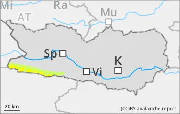
Danger level
Avalanche Problem
Wet snow
Rapidly rising daytime danger of wet-snow avalanches.
Due to daytime warming and solar radiation, increasingly frequent wet-snow avalanches can be expected, mostly small-sized releases, esp. on steep E/S/W-facing slopes. In the morning: beware falls on the hardened crusts.
Snowpack
dp.10: springtime scenario
Clear skies over far-reaching areas, surface crusts will form and freeze which are capable of bearing loads. Sunshine and warmth will rapidly soften the snowpack on E/W/S-facing slopes during the daytime. The snowpack at low and intermediate altitudes is thoroughly wet. Below 1600m there is hardly any snow on the ground.
Tendency
Little change in avalanche danger levels anticipated