Snow still powdery only on high-altitude shady slopes
Avalanche danger above 2200m is moderate in the morning, rises in the afternoon from low to moderate at all altitudes. Snowdrift accumulations are the major problem, esp. on sunny, extremely steep slopes where slab avalanches can trigger naturally. Frequency of danger zones increases during the course of the day. Avalanches can grow to medium size. In some places, snowdrifts can trigger a slab avalanches by large additional loading. Danger zones occur in steep ridgeline terrain and in wind-loaded gullies and bowls, releases can reach medium size. On very steep grass-covered slopes and on very steep smooth ground, glide-snow avalanches can be expected, these can reach medium size in isolated cases.
Snowpack
A thin melt-freeze crust forms during the nighttime hours, then softens swiftly in the morning sunshine. During the day, mild temperatures up to high altitudes are moistening the snowpack, causing it to forfeit its firmness. Older snowdrift accumulations have consolidated somewhat. In many places graupel is embedded which can be prone to triggering. Snow is still powdery only on high-altitude shady slopes. At intermediate altitudes the fresh fallen snow was frequently deposited on moist ground which was previously bare of snow. Gliding movements are possible.
Tendency
Temperatures will drop on the weekend, the snowpack will stabilize somewhat.
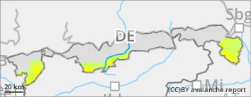
BEFORE NOON Danger level
Avalanche Problem
Wet snow
Wind slab
1800m
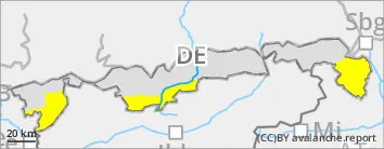
AFTERNOON Danger level
Avalanche Problem
Wet snow
Wind slab
1800m
Snow becoming moist also on shady slopes
Avalanche danger rises from low to moderate during the afternoon hours. Wet snow is the main problem. Due to daytime warming, mostly small, wet loose snow slides trigger naturally on extremely steep slopes. Frequency of danger zones increases during the daytime hours. At high altitudes, snowdrifts can be a problem, they can be triggered as small slab avalanches in steep ridgeline terrain and in wind-loaded gullies and bowls by large additional loading. On very steep grass-covered slopes, isolated small glide-snow avalanches are possible.
Snowpack
A thin melt-freeze crust forms during the nighttime hours, then softens swiftly in the morning sunshine. During the day, mild temperatures up to high altitudes are moistening the snowpack, causing it to forfeit its firmness. Older snowdrift accumulations have consolidated somewhat. In many places graupel is embedded which can be prone to triggering. At intermediate altitudes the snowpack is deposited on wet ground. South-facing slopes are becoming bare of snow.
Tendency
Temperatures will drop on the weekend, the snowpack will stabilize somewhat.
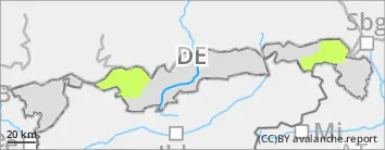
Danger level
Avalanche Problem
Wet snow
Snowpack is becoming wetter and wetter
Avalanche danger is low. Wet snow is the major problem. Due to daytime warming, mostly small, wet loose snow slides trigger naturally on extremely steep slopes. On very steep grass-covered slopes, isolated small glide-snow avalanches can trigger naturally.
Snowpack
During the night, a melt-freeze crust will form, then swiftly melt in the sunshine next morning. Older snowdrift accumulations have consolidated somewhat. In many places graupel is embedded. At intermediate altitudes the fresh fallen snow was frequently deposited on moist ground which was previously bare of snow. South-facing slopes are losing their snow cover.
Tendency
Avalanche danger is not expected to change significantly.