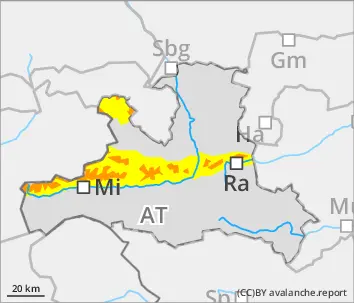
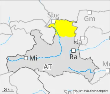
Unfavorable avalanche situation above the timberline
Avalanche danger is considerable above the treeline, avalanches can be triggered by one sole skier in places and grow to large size. Fresh snowdrift accumulations lie deposited behind protruberances in the terrain, and in gullies and bowls. Danger zones in the old snow occur on north-facing slopes above 2200m, above 2400m in all aspects. Small to medium-sized glide-snow avalanches can trigger naturally in very steep grass-covered terrain.
Snowpack
During the day on Monday, 20-30cm of fresh snow with wind impact expected at high altitudes. Inside the snowdrifts, trigger-sensitive weak layers are forming. Below 2000m the old snow is moist, often there is a crust on the surface. Where the ground was bare of snow prior to this precipitation, the entire mass of fresh fallen snow can glide away.
Tendency
Proneness of snowdrifts triggering will decrease slightly on Tuesday
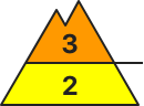
Danger level
treeline
Avalanche Problem
Wind slab
Treeline
Gliding snow
Fresh snow and drifts often deposited atop an unfavorable old snowpack surface
Avalanche danger above the treeline is CONSIDERABLE, below that altitude danger is moderate. Avalanches can in some zones be triggered by one sole skier, esp. in the afternoon, and grow to medium size. Danger zones occur in the old snow on north-facing slopes above 2200m, in all aspects above 2400m. Above 2200m weak layers can be swept away with the releases and the avalanches thereby grow to large size. Small-to-medium glide-snow avalanches can trigger naturally in very to extremely steep grass-covered terrain.
Snowpack
During the day on Monday, 20-30cm of fresh snow with wind impact expected at high altitudes. Inside the snowdrifts, trigger-sensitive weak layers are forming. Below 2200m on north-facing slopes there are faceted crystals in the lowermost part of the snowpack. Above 2400m on W/S/E-facing slopes there are faceted crystals between crusts. Below 2000m the old snow is moist, often there is a crust on the surface. Where the ground was bare of snow prior to this precipitation, the entire mass of fresh fallen snow can glide away.
Tendency
Proneness of snowdrifts triggering will decrease slightly on Tuesday
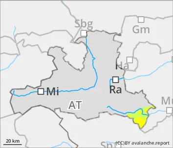
Danger level
treeline
Avalanche Problem
Wind slab
Treeline
New snow
Unfavorable avalanche situation
Avalanche danger above the treeline is CONSIDERABLE, below that altitude danger is moderate. Avalanches can in some zones be triggered by one sole skier, esp. in the afternoon, and grow to medium size. Danger zones occur in the old snow on north-facing slopes above 2200m, in all aspects above 2400m. Above 2200m weak layers can be swept away with the releases and the avalanches thereby grow to large size. Small-to-medium glide-snow avalanches can trigger naturally in very to extremely steep grass-covered terrain.
Snowpack
At high altitudes 30-50cm of further fresh snow with wind impact is expected. Inside the drifts, trigger-sensitive weak layers can rapidly form. Above 2200m on north-facing slopes there are weak layers of faceted crystals in the lowermost part of the snowpack. Above 2400m on W/S/E-facing slopes there are weak layers of faceted crystals between crusts. Below 2000m the old snowpack is moist, on the surface a crust has formed. Where the ground was bare of snow before this round of precipitation, the entire snowpack can now glide away.
Tendency
Proneness of snowdrifts triggering will decrease slightly on Tuesday
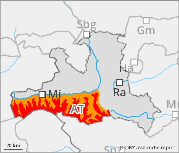
Danger level
treeline
Avalanche Problem
Wind slab
Treeline
Gliding snow
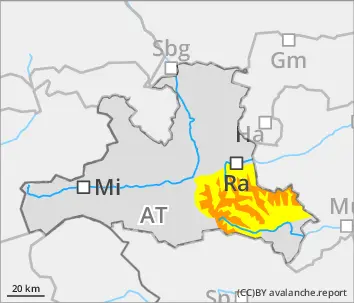
Natural gliding snow activity and trigger-sensitive snowdrift accumulations at high altitude
Avalanche danger is moderate. Glide-snow and loose-snow avalanches can trigger naturally on some very steep slopes and then grow to medium size. Above the timberline the fresh snowdrifts are prone to triggering and can be released by one sole skier. Avalanches can reach medium size in isolated cases.
Snowpack
At high altitudes 20-40cm of further fresh snow with wind impact is expected. Prior to the precipitation on sunny slopes there was no snow on the ground, snow on shady slopes was thoroughly wet. Inside the drifts, trigger-sensitive weak layers can rapidly form. Where the ground was bare of snow before this round of precipitation, the entire snowpack can now glide away.
Tendency
Proneness of snowdrifts triggering will decrease slightly on Tuesday
Danger level
treeline
Avalanche Problem
Wind slab
Treeline
Persistent weak layer
2200m
Daytime increase in avalanche danger. In high-alpine regions: beware hidden weak layers.
Daytime warming and solar radiation lead to increasing avalanche danger during the course of the day. In early morning, danger above 2300m is moderate, below that altitude danger is low. During the daytime it rises at all altitudes to moderate. Below 2400m, increasingly frequent small-to-medium wet-snow avalanches are possible in as aspects on steep slopes. In zones which have not yet discharged, also higher up. Small-to-medium glide-snow avalanches can trigger naturally on very steep grass-covered slopes. Above 2300m in some places, dry slab avalanches can be triggered even by one sole skier. Danger zones occur in very steep terrain and on liitle-tracked NW/NE facing slopes. Releases can fracture in the old snowpack and down to more deeply embedded layers, thereby reaching medium size.
Avalanche danger is moderate. Wet-snow avalanches can be triggered by one sole skier on steep slopes in all aspects in steep sunny terrain which has not yet discharged. Small-to-medium glide-snow avalanches can trigger naturally on extremely steep grass-covered slopes. Above 2300m, dry slab avalanches can still be triggered by one sole skier. Danger zones occur on very steep, little-tracked slopes on NW/NE facing slopes. Avalanches can fracture down to more deeply embedded layers in the snowpack and reach medium size. Small freshly generated snowdrift patches are often prone to triggering, esp. on very steep shady slopes in high-alpine ridgeline terrain. Apart from the danger of being buried in snow masses, the risks of being swept along and forced to take a fall demand adequate consideration.
Snowpack
The snowpack cools at night and forms a melt-freeze crust which is usually capable of bearing loads. During the daytime the snowpack then softens and forfeits its bonding. On shady slopes at high and high-alpine altitudes there are several weak layers of facted crystals inside the old fundament. Also moist slabs can slide away on sunny slopes over the surface crusts.
Tendency
Dense clouds at night, the snowpack can hardly cool. Snowfall will set in. Avalanche danger will increase during the course of the day.
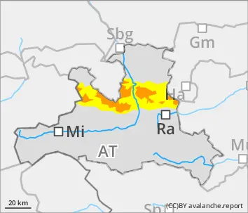
Avalanche danger above 2200m is HIGH. The situation is dangerous for winter sports enthusiasts, slab avalanches can be triggered by minimum additional loading and grow to medium size, also isolated naturally triggered avalanches from ridgeline snowdrifts are possible. Near-surface slab avalanches in fresh snow and drifts can fracture down to deeper layers above 2200m on W/N/E-facing slopes and grow to large size. Due to solar radiation in afternoon hours, naturally triggered loose-snow avalanches can be expected. Avalanches released at higher altitudes can fracture down to deeper layers and then plummet down to green zones. Especially above the timberline, small-to-medium glide-snow avalanches can trigger naturally in very steep grass-covered terrain.
Snowpack
Since Friday evening 30-50cm of fresh snow has been registered at high altitudes. By Monday evening another 30-60cm is anticpated. Winds will be strong-to-stormy from the northwest. Inside the fresh snow and snowdrifts there are soft layers of loose snow or graupel. In the lower and middle parts of the snowpack above 2200m there are weak layers of faceted crystals which are embedded between cdrusts. Below 2000m the old snow is moist.
Tendency
As precipitation tapers off, avalanche danger will decrease