Daytime increase in avalanche danger due to fresh snow and wind
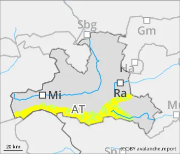
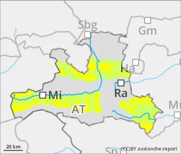
Avalanche danger during the morning will be moderate above 2200m, below that altitude danger is low. With increasing amounts of fresh fallen snow, avalanche danger above 2200m will rise to CONSIDERABLE. Avalanches can in some zones be triggered by one sole skier, esp. in the afternoon, and grow to medium size. Danger zones occur in the old snow on north-facing slopes above 2200m, in all aspects above 2400m. Fresh snowdrift accumulations occur both near to and distant from ridgelines, behind protruberances in the terrain, and in gullies and bowls. Particularly below 2000m the old snowpack is thoroughly wet and small-to-medium wet-snow avalanches are possible. Avalanches in high altitudes can sweep along more deeply embedded layers of the snowpack and in isolated cases plummet all the way down to the green zones. Small-to-medium glide-snow avalanches can trigger naturally in very to extremely steep grass-covered terrain.
Snowpack
By Saturday evening 30cm of fresh snow is anticipated at high altitudes. Above 2200m on north-facing slopes weak layers of faceted crystals are found in the lowermost part of the snowpack. Above 2400m on W/S/E facing slopes there are faceted crystals between crusts. Inside the snowdrifts, in addition, trigger-sensitive layers can form rapidly. Below 2000m the snowpack will forfeit its firmness on Friday night due to rainfall and water seepage.
Tendency
On Saturday night, increase in avalanche danger due to fresh snow and wind
BEFORE NOON Danger level
AFTERNOON Danger level
2000m
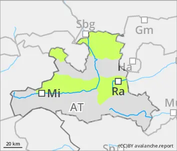
Avalanche Problem
Wind slab
2000m
Daytime increase in avalanche danger due to fresh snow and wind
Avalanche danger is low during the morning hours During the daytime, danger above 2000m will rise to moderate. Where winds transport the fresh fallen snow, avalanches can be triggered even by one sole skier and in isolated cases grow to medium size. Fresh snowdrift accumulations occur both near to and distant from ridgelines, behind protruberances in the terrain, and in gullies and bowls. Particularly below 2000m the old snowpack is thoroughly wet and small-to-medium wet-snow avalanches are possible. Avalanches in high altitudes can sweep along more deeply embedded layers of the snowpack and in isolated cases plummet all the way down to the green zones. Small-to-medium glide-snow avalanches can trigger naturally in very to extremely steep grass-covered terrain.
Snowpack
By Saturday evening 15-20cm of fresh snow is anticipated at high altitudes. Above 2200m on north-facing slopes weak layers of faceted crystals are found in the lowermost part of the snowpack. Above 2400m on W/S/E facing slopes there are faceted crystals between crusts. Inside the snowdrifts, in addition, trigger-sensitive layers can form rapidly. Inside the snowdrifts, in addition, trigger-sensitive layers can form rapidly. Below 2000m the snowpack will forfeit its firmness on Friday night due to rainfall and water seepage.
Tendency
On Saturday night, increase in avalanche danger due to increasing amounts of fresh snow and wind
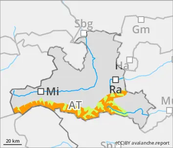
BEFORE NOON Danger level
2200m
Avalanche Problem
Persistent weak layer
2200m
Wind slab
2200m
AFTERNOON Danger level
2200m
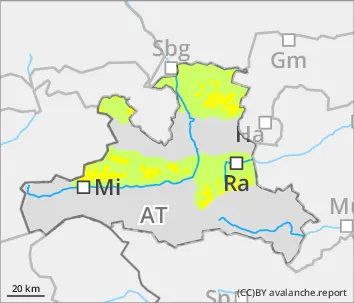
Avalanche Problem
Persistent weak layer
2200m
Wind slab
2200m
Daytime increase in avalanche danger due to fresh snow and wind
Avalanche danger will be moderate above 2200m, below that altitude danger is low. With increasing amounts of fresh fallen snow, avalanche danger above 2200m will rise to CONSIDERABLE. Avalanches can in some zones be triggered by one sole skier, esp. in the afternoon, and grow to medium size. Danger zones occur in the old snow on north-facing slopes above 2200m, in all aspects above 2400m. Fresh snowdrift accumulations occur both near to and distant from ridgelines, behind protruberances in the terrain, and in gullies and bowls. Particularly below 2000m the old snowpack is thoroughly wet and small-to-medium wet-snow avalanches are possible. Avalanches in high altitudes can sweep along more deeply embedded layers of the snowpack and in isolated cases plummet all the way down to the green zones. Small-to-medium glide-snow avalanches can trigger naturally in very to extremely steep grass-covered terrain.Avalanche danger is moderate. Wet-snow avalanches can be triggered by one sole skier on steep slopes in all aspects in steep sunny terrain which has not yet discharged. Small-to-medium glide-snow avalanches can trigger naturally on extremely steep grass-covered slopes. Above 2300m, dry slab avalanches can still be triggered by one sole skier. Danger zones occur on very steep, little-tracked slopes on NW/NE facing slopes. Avalanches can fracture down to more deeply embedded layers in the snowpack and reach medium size. Small freshly generated snowdrift patches are often prone to triggering, esp. on very steep shady slopes in high-alpine ridgeline terrain. Apart from the danger of being buried in snow masses, the risks of being swept along and forced to take a fall demand adequate consideration.
Snowpack
By Saturday evening 30cm of fresh snow is anticipated at high altitudes. Above 2200m on north-facing slopes weak layers of faceted crystals are found in the lowermost part of the snowpack. Above 2400m on W/S/E facing slopes there are faceted crystals between crusts. Inside the snowdrifts, in addition, trigger-sensitive layers can form rapidly. Below 2000m the snowpack will forfeit its firmness on Friday night due to rainfall and water seepage.
Tendency
On Saturday night, increase in avalanche danger due to increasing amounts of fresh snow and wind