Small-area snowdrifts and wet-snow avalanches during daytime: caution
Fresh snowdrift accumulations have been generated this weekend which are often prone to triggering. One sole winter sports enthusiast can trigger mostly small slab avalanches in these zones. Apart from the danger of being buried in snow masses, the risks of being swept along and forced to take a fall require adequate caution. Less danger on steep grass-covered slopes with sufficient snow, isolated medium-sized glide-snow avalanches still possible. With daytime warming and solar radiation, small-to-medium wet-snow avalanches are possible in steep terrain.
Snowpack
Nighttime hours initially will have good outgoing longwave radiation, later on it will be reduced due to heavy cloud. Especially on sunny slopes the uppermost layers will moisten during the daytime hours due to diffuse radiation and low-lying clouds. In addition, rainfall at intermediate altitudes will weaken the snowpack. were foehn-impacted and warm, often reducing outgoing longwave radiation so that only a breakable crust could form. In addition, light rainfall up to intermediate altitudes. Below 1500m there is little snow on the ground. Shady slopes at high and high-alpine altitudes were impacted by strong-velocity foehn winds over the weekend, the newly generated snowdrifts were deposited atop an unfavorable old snowpack surface, which is stabilizing gradually.
Tendency
Glide-snow and wet-snow avalanches still possible, despite lower temperatures
Danger level
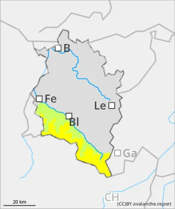
1500m
Avalanche Problem
Wet snow
1500m
Wind slab
2200m
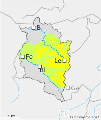
Wet and glide-snow snow avalanches during daytime
Due to daytime warming and often diffuse radiation, mostly small-sized wet-snow avalanches are possible in steep terrain. On steep grass-covered slopes where there is sufficient snow, in addition, danger of small, in isolated cases medium-sized glide-snow avalanches threatens. On shady high-altitude slopes, mostly small snowdrift accumulations are prone to triggering in isolated cases. One sole skier can trigger a small slab avalanche in these zones. Apart from the danger of being buried in snow masses, the risks of being swept along and forced to take a fall require adequate caution.
Snowpack
Nighttime hours initially will have good outgoing longwave radiation, later on it will be reduced due to heavy cloud. Especially on sunny slopes the uppermost layers will moisten during the daytime hours due to diffuse radiation and low-lying clouds. In addition, rainfall at intermediate altitudes will weaken the snowpack. were foehn-impacted and warm, often reducing outgoing longwave radiation so that only a breakable crust could form. In addition, light rainfall up to intermediate altitudes. Below 1500m there is little snow on the ground. Shady slopes at high and high-alpine altitudes were impacted by strong-velocity foehn winds over the weekend, the newly generated snowdrifts were deposited atop an unfavorable old snowpack surface.
Tendency
Glide-snow and wet-snow avalanches still possible, despite lower temperatures
Danger level
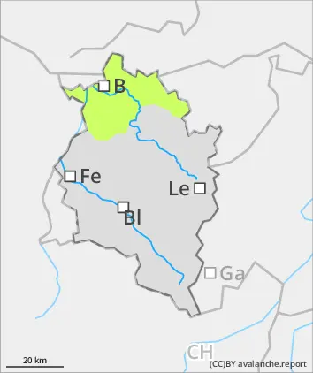
Not much snow, low avalanche danger
Avalanche danger is low. In isolated cases, small loose-snow avalanches can trigger naturally in extremely steep terrain.
Snowpack
The shallow snowpack is moist up to summit level, often wet. Gliding movements over wet, smooth ground are possible. A cohesive, area-wide snowpack is generally only evident on shady slopes above 1400m. It is well consolidated by and large. South-facing slopes are largely bare of snow on the ground.
Tendency
Avalanche danger levels expected to remain unchanged