Rising danger of moist/wet avalanches due to rainfall. Attention: weak layers in old snow.
Due to rainfall, increasingly frequent moist/wet-snow avalanches are possible, esp. on steep slopes in all aspects below 2000m. Releases are relatively small and can be triggered in the old snow even by one sole skier. Such danger zones lie on very steep shady slopes and in transitions into gullies and bowls above 1900m on steep N/W/E facing slopes and in gullies and bowls and can reach medium size.
Snowpack
dp.3: rain dp.1: deep persistent weak layer
More rainfall was registered than expected, but more is still expected, along with some snowfall esp. at high altitudes. Nocturnal outgoing longwave radiation is nearly absent. The snowpack is moist. In the lowermost part of the snowpack there are faceted, expansively metamorphosed weak layers evident, esp. above 2000.
Tendency
Attention: wet snow and weak layers in the old snow
Danger level
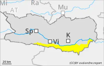
2000m
Avalanche Problem
Wet snow
2000m
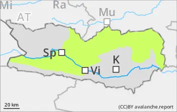
Persistent weak layer
2000m
Moist/wet-snow avalanches still possible. Caution urged towards weak layers in old snow.
Due to rainfall and the snowpack which is becoming thoroughly wet, increasingly frequent moist/wet-snow avalanches are possible, esp. on steep slopes in all aspects below 2000m. Releases are relatively small and can be triggered in the old snow even by one sole skier. Such danger zones lie on very steep shady slopes and in transitions into gullies and bowls above 2000m on steep N/W/E facing slopes and in gullies and bowls and can reach medium size. In addition, small snowdrifts accumulations require attentiveness, esp. at high altitudes.
Snowpack
dp.3: rain dp.1: deep persistent weak layer
Heavy snowfall (up to 20cm) over 2000m, some rainfall, more is expected esp. at high altitudes. Nocturnal outgoing longwave radiation is nearly absent. The snowpack is moist. In the lowermost part of the snowpack there are faceted, expansively metamorphosed weak layers evident, esp. at high altitudes. In the middle part of the snowpack on N/W/E facing slopes there are facted weak layers, esp. above 2000m. Due to fresh snowfall and moderate-to-strong velocity southerly winds, small snowdrift accumulations will be generated esp. in ridgeline terrain.
Tendency
Beware wet snow and weak old snow
Danger level
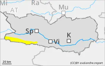
2200m
Avalanche Problem
Persistent weak layer
2200m
Wind slab
2500m
Wet snow
2200m
Caution: weak layers in the old snow, fresh snowdrifts at high and high-alpine altitudes
Weak layers can be triggered in the old snow even by one sole skier. Such danger zones lie on N/W/E facing very steep shady slopes and in transitions into gullies and bowls above 2200m. Very isolated danger zones also occur on very steep sunny slopes above 2600m. Avalanches can in isolated cases reach medium size. In addition, fresh snowdrift accumulations require attentiveness, esp at high and high-alpine altitudes. Due to snowpack moistening, isolated moist loose-snow avalanches are possible, esp. on very steep slopes, small releases.
Snowpack
dp.1: deep persistent weak layer dp.6: cold, loose snow and wind
5-10cm fresh snow was registered, and some rainfall. More snowfall is anticipated, esp. at high altitudes. In the middle part of the snowpack on N/W/E facing slopes there are faceted weak layers, esp above 2200m. Due to fresh snowfall and moderate-to-strong velocity southerly winds, small snowdrift accumulations were generated esp. in ridgeline terrain. Nocturnal outgoing longwave radiation hardly exists, which leads to increasing moistening of the snowpack esp. below 2200m.
Tendency
Attention: weak old snow and fresh snowdrifts
Danger level
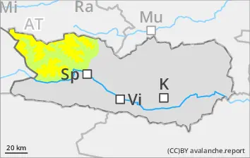
2000m
Avalanche Problem
Wet snow
2000m
Beware wet snow
Since the snowpack is becoming thoroughly wet, moist/wet avalanches can be triggered in the old snow even by one sole skier in all aspects on very steep shady slopes and in transitions into gullies and bowls, esp at high altitudes. Isolated danger zones occur esp. on very steep shady slopes at high altitudes.
Snowpack
dp.3: rain dp.1: deep persistent weak layer
Some rainfall below 2000m, and some snowfall, esp. at high altitudes. Nocturnal outgoing longwave radiation is nearly absent. The snowpack is moist. In the lowermost part of the snowpack there are faceted, expansively metamorphosed weak layers evident, esp. above 2000.