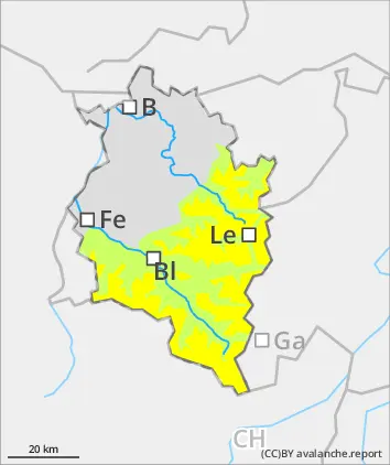
Caution: freshly generated snowdrift accumulations at high altitudes
Fresh snow and drifts are triggerable esp. on steep shady slopes. One sole skier can trigger a small-to-medium loose-snow or slab avalanche. Apart from the danger of being buried in snow masses, the risks of being swept along and forced to take a fall require adequate caution. On steep grass-covered slopes with sufficient snow on the ground or atop smooth ground, isolated small-to-medium glide-snow avalanches are possible. In rocky terrain, slides and small loose-snow avalanches are possible.
Snowpack
The fresh snow which has fallen since Thursday has in the interim settled and increasingly consolidated at intermediate altitudes due to solar radiaiton. On steep slopes it is still loose and soft. Fresh snow and small drifts lie deposited on shady slopes atop expansively metamorphosed, soft layers, often blanketing graupel, bonding only moderately good. The below average snowpack is well consolidated. On sunny slopes and at lower altitudes the fresh snow will fall on bare ground.
Tendency
Monday will be cool, increased sunshine expected as the day unfolds, with moderate-to-brisk E/NE winds. Thus, more snowdrifts will be generated at high altitudes.
Danger level
treeline
Avalanche Problem
Wind slab
Treeline
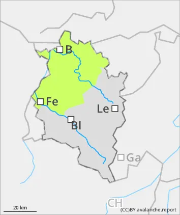
Caution: small-area drifts above the timberline
Fresh snow and drifts are trigger-sensitive esp on shady steep slopes, small-to-medium avalanches can be triggered by winter sports enthusiasts in steep terrain. Danger zones occur esp. on ridgeline shady steep slopes and in extremely steep terrain. Apart from the danger of being buried in snow masses, the risks of being swept along and forced to take a fall require adequate caution. On steep grass-covered slopes with sufficient snow on the ground or atop smooth ground, increasingly frequent small-to-medium glide-snow avalanches are possible.
Snowpack
At high altitudes 20-30 cm of fresh snow was registered by Friday evening. During the night and on Saturday, another 5cm is expected regionally, accompanied by moderate-velocity winds which will deposited fresh snowdrifts atop soft layers on shady slopes, often with blanketed graupel, bonding only moderately good. The below average snowpack is well consolidated. On sunny slopes and at lower altitudes the fresh snow will fall on bare ground.
Tendency
Monday will be cool, increased sunshine expected as the day unfolds, with moderate-to-brisk E/NE winds. Avalanche danger levels not expected to change significantly.