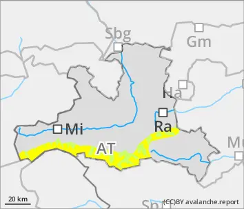
Avoid snowdrift accumulations on north-facing slopes
Avalanche danger above 2000m is moderate, below that altitude danger is low. Small to medium slab avalanches can be triggered by one sole skier. Danger zones occur esp. on NW/N/E facing slopes, esp. near ridgelines on occasion distant from ridgelines. Caution urged esp. at entry points into very steep gullies and bowls. During the course of the day, naturally triggered loose-snow avalanches can be expected in extremely steep south-facing terrain below 2800m. On steep grass-covered slopes, isolated small glide-snow avalanches are possible in isolated cases. On steep grass-covered slopes isolated small glide-snow avalanches are possible.
Snowpack
In foehn-exposed areas, trigger-sensitive snowdrifts lie deposited at high altitudes on steep shady slopes atop expansively metamorphosed old snowpack layers. On sunny slopes there forms a thin melt-freeze crust at night - sometimes capable of bearing loads - which softens during the daytime, becomes moist, and can forfeit bonding.
Tendency
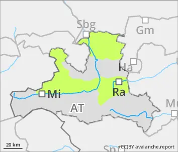
On Sunday night, clouds will move in, only limited gain in snowpack firmness on south-facing slopes. Above 2000m a bit of fresh snow is expected, further down light rainfall, which will heighten the wet/gliding snow problem.
Danger level
Avalanche Problem
Wet snow
Generally favorable avalanche situation, only few danger zones
Avalanche danger is low. Isolated danger zones occur near ridgelines, esp. in steep shady terrain at summit level. Apart from the danger of being buried in snow masses, the risks of being swept along and forced to take a fall demand adequate consideration. During the course of the day, small loose-snow slides continue to be possible. On steep grass-covered slopes, isolated small glide-snow avalanches are possible.
Snowpack
On shady slopes at high altitudes, isolated weak layers in transitions from old to fresh snow. On sunny slopes and at lower altitudes the bonding of fresh snow to old snow is generally good, the snowpack is often moistened and forms a thin melt-freeze crust during the night. During the course of the day, this crust softens, the surface becomes moist and can forfeit its bonding.
Tendency
On Sunday night, clouds will move in, only limited gain in snowpack firmness on south-facing slopes. Above 2000m a bit of fresh snow is expected, further down light rainfall, which will heighten the wet/gliding snow problem in Lungau and Tauern.
Danger level
2000m
Avalanche Problem
Wind slab
2000m
Wet snow
2800m
Generally favorable avalanche situation, isolated danger zones on shady slopes
Avalanche danger is low. Freshly generated snowdrift accumulations can be trigger a small slab avalanche in steep terrain by one sole skier and reach medium size where snow is sufficient. Danger zones occur esp. on NW/N/E facing slopes above 2000m. Danger zones often blanketed, making them difficult to recognize. Caution especially at entry points into very steep gullies and bowls. During the course of the day, naturally triggered loose-snow avalanches are possible in all aspects, esp. in extremely steep south-facing terrain below 2800m, releases will be generally small-sized. On steep grass-covered slopes, very isolated small glide-snow avalanches are possible.
Snowpack
The settled fresh snow has been deposited on steep shady slopes above 2400m atop an expansively metamorphosed snowpack which is prone to triggering in places. On sunny slopes and at lower altitudes, the bonding of fresh fallen snow to the old snowpack is generally good, the surface moistens during the daytime, forms a thin melt-freeze crust at night - not capable of bearing loads - and can forfeit bonding. The crust softens up during the daytime, the snowpack becomes superficially moist, forfeits its bonding.
Tendency
On Sunday night, clouds will move in, only limited gain in snowpack firmness on south-facing slopes. Above 2000m a bit of fresh snow is expected, further down light rainfall, which will heighten the wet/gliding snow problem, esp. in the Tauern.