As snowfall intensifies, likelihood of slab avalanches above 1900m rising significantl, esp. on ridgeline W/N/E facing slopes where snow is heavy. triggerable by persons. Where snwofall is heaviest natural triggerings possible.. Danger zones difficult to recognize. Isolated whump noises are warning.
Snowpack
dp.1: deep persistent weak layer
Since Wednesday above 1600m: 10-15 cm of fresh snow, tonight anothern 15-30 cm is expected, locally more. Fresh snow and drifts lie deposited on W/N/E facing slopes above 1900m atop an unfavorable old snowpack. South-facing slopes and terrain below 1900m: atop a crust.
Tendency
Natural triggerings will recede
Danger level
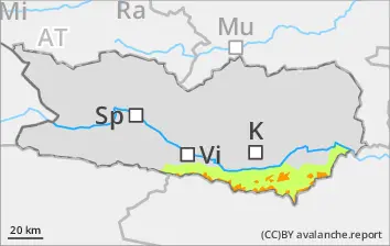
1900m
Avalanche Problem
Persistent weak layer
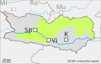
1900m
Avalanche danger rising
As snowfall intensifies, likelihood of slab avalanches above 1900m rising significantl, esp. on ridgeline W/N/E facing slopes where snow is heavy. triggerable by persons. Where snwofall is heaviest natural triggerings possible.. Danger zones difficult to recognize. Isolated whump noises are warning.
Snowpack
dp.1: deep persistent weak layer
Since Wednesday above 1600m: 10-15 cm of fresh snow, tonight anothern 15-30 cm is expected, locally more. Fresh snow and drifts lie deposited on W/N/E facing slopes above 1900m atop an unfavorable old snowpack. South-facing slopes and terrain below 1900m: atop a crust.
Tendency
Avalanche danger levels rising
Danger level
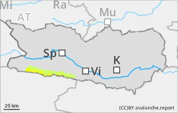
2200m
Avalanche Problem
Persistent weak layer
2200m
Wind slab
2000m
Caution: weak layers in old snowpack
As a result of snowfall, likelihood of slab avalanches triggering increasing, esp. in ridgline W/N/E facing slopes above 2200m. Avalanches can be triggered by persons and reach medium As snowfall intensifies, likelihood of slab avalanches above 1900m rising significantl, esp. on ridgeline W/N/E facing slopes where snow is heavy. triggerable by persons. Where snwofall is heaviest natural triggerings possible.. Danger zones difficult to recognize. Isolated whump noises are warning.. Caution urged in transitions from shallow to deeper snow in the regions where it is windy. Danger zones are difficult to recognize. Isolated whumpf noises can indicate imminent danger.
Snowpack
dp.1: deep persistent weak layer
Since Wednesday above 1600m: 10-15 cm of fresh snow, tonight anothern 15-30 cm is expected, locally more. Fresh snow and drifts lie deposited on W/N/E facing slopes above 1900m atop an unfavorable old snowpack. South-facing slopes and terrain below 1900m: atop a crust.
Tendency
Avalanche danger rising
Danger level
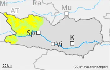
2000m
Avalanche Problem
Persistent weak layer
2000m
Avalanche danger rising
As a result of snowfall, likelihood of slab avalanches triggering increasing, esp. in ridgline NW/N/NE facing slopes above 2000m. Avalanches can be triggered by persons and reach medium size, esp. by large additional loading.
Snowpack
dp.1: deep persistent weak layer
5-10cm of fresh snow is anticipated, locally more. Fresh snow and freshly generated snowdrifts lie deposited on W/N/W facing slopes above 2200m atop a weak old snowpack surface. The old snowpack is expansively metamorphosed with a loosely-packed surface of surface hoar and faceted crystals. South-facing slopes below 2000m: fresh snow and drifts are being deposited atop a crust.