Slightly increasing avalanche danger levels due to fresh snowfall and newly generated drifts
On Thursday avalanche danger levels will increase to moderate. Fresh snow and newly generated drifts will increase in frequency with ascending altitude, often poorly bonded with the snowpack surface. Triggerings of small-to-medium loose-snow and slab avalanches are possible by the loading of one sole skier. Apart from the risks of being buried in snow masses, the dangers of being swept along and forced to take a fall need adequate consideration. The danger of small, in isolated cases medium-sized glide-snow avalanches continues to be difficult to assess, for that reason avoid zones below glide cracks.
Snowpack
By Thursday evening, 10-20 cm of fresh snow is expected, deposited atop a well-consolidated old snowpack. On wind-protected shady slopes the fresh snow will blanket the powdery layers, often a breakable or non-breakable wind crust and on steep sunny slopes a melt-freeze crust. In ridgeline and pass areas, fresh snowdrifts will be generated over small areas under the impact of intermittently strong-velocity winds.
Tendency
Avalanche danger levels to increase somewhat on Friday, due to fresh snowfall and wind
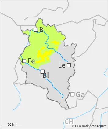
Danger level
2200m
Avalanche Problem
Persistent weak layer
2200m
Wind slab
2000m
Caution urged in steep shady terrain seldom skied on
Avalanche danger mostly low. Danger zones occur mostly in steep shady terrain above 2200m, in transitions from shallow to deep snow and in areas with shallow snow. Activities in backcountry demand cautious route selection, particularly in shady steep terrain seldom skied on. Freshly generated snowdrift accumulations are prone to triggering in some places, require attentiveness in steep terrain.The danger of small-to-medium sized glide-snow avalanches continues to be difficult to assess. Caution urged below glide cracks.
Snowpack
Up to 5 cm of snowfall is anticipated, deposited atop a well consolidated old snowpack surface at high altitudes. On shady slopes there are weak layers in the uppermost part of the snow cover or at ground level, these can be triggered in some cases. On wind-protected shady slopes the fresh snow will blanket the powdery layers, often a breakable or non-breakable wind crust and on steep sunny slopes a melt-freeze crust. In ridgeline and pass areas, fresh snowdrifts will be generated over small areas under the impact of intermittently strong-velocity winds.
The snowpack is well consolidated up to high altitudes. Particularly on shady slopes there are weak layers evident which can easily be triggered. Snowpack surfaces are often powdery on shady, wind-protected slopes. Elsewhere there are wind crusts and a melt-freeze crust evident. Elsewhere a wind crust is evident which is often capable of bearing loads, on sunny slopes there is a melt-crust. Small snowdrift accumulations are evident. During the course of the day, the superficially encrusted snowpack will moisten/soften on steep sunny slopes. Small-area fresh snowdrifts have been generated.
Tendency
Avalanche danger levels to increase somewhat on Friday, due to fresh snowfall and wind
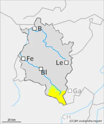
Danger level
treeline
Avalanche Problem
New snow
Treeline
Wind slab
Treeline
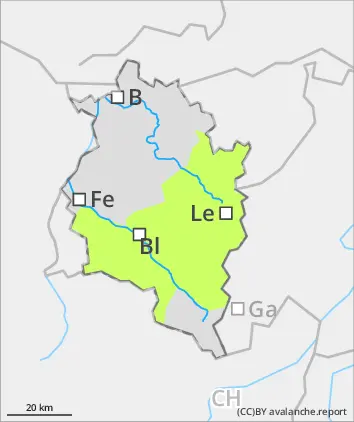
Slightly increasing avalanche danger. Freshly generated drifts over small areas.
Avalanche danger continues to be low. The small amounts of fresh snow and small-sized snowdrift accumulations are often poorly bonded with the old snowpack surface. Triggering slides, small loose-snow avalanches and the drifts is possible through the loading of one sole skier. Apart from the risks of being buried in snow masses, the danger of being swept along and forced to take a fall need due consideration. The danger of small, in isolated cases medium-sized glide-snow avalanches is difficult to estimate. Caution urged below glide-cracks.
Snowpack
By Thursday evening, 10-20 cm of fresh snow is expected, deposited atop a well-consolidated old snowpack. On wind-protected shady slopes the fresh snow will blanket the powdery layers, often a breakable or non-breakable wind crust and on steep sunny slopes a melt-freeze crust. In ridgeline and pass areas, fresh snowdrifts will be generated over small areas under the impact of intermittently strong-velocity winds.
Tendency
Avalanche danger levels to increase further on Friday, due to fresh snowfall and wind