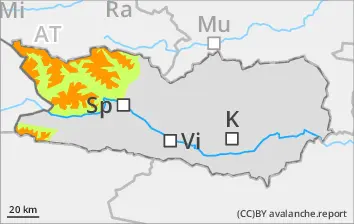
Avalanches can be treiggered even by one sole skier, esp. on shady wind-protected slopes. Isolated danger zones occur also on sunny slopes which are little skied on in high alpine terrain, in isolated cases releases can grow to large size. Remote triggerings are possible, particularly treacherous are the foot of rock walls. A defensive route selection is important. In addition, on wind-loaded slopes, surface layers can be triggered in some places, the releases mostly small but easily triggered. In the major areas of precipitation, isolated and mostly small glide-snow avalanches are possible.
Snowpack
dp.1: deep persistent weak layer dp.6: cold, loose snow and wind
Shady wind-protected slopes above 2400m: in the lower part of the old snowpack there are faceted expansively metamorphosed weak layers evident. On shady slopes where the snow is rather shallow above 1800m: fresh snow and drifts blanket a weak old snowpack. Shady slopes below 1800m: the fresh snow lies atop a hardened crust.
Tendency
Little change is expected in avalanche danger levels
Danger level
1800m
Avalanche Problem
Persistent weak layer
1800m
Caution: weak layers in old snowpack
Avalanches can be triggered by one sole skier in some places, particularly on shady wind-protected slopes in zones. Danger zones and likelihood of triggering tned to increase with ascending altitude. Avalanches can grow to medium size. In addition, in places avalanches can be triggered in the surface layers, releases usually small but easily triggerable.
Snowpack
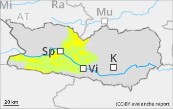
dp.6: cold, loose snow and wind dp.4: cold following warm / warm following cold
Snowfall (5-10cm) is expected, locally more. The SW winds will transport the fresh snow. On shady slopes above 1800m: snowdrift accumulations are often poorly bonded with the old snowpack. In the lower part of the snowpack there are faceted expansively metamorphosed weak layers evident. On shady slopes below 1800m: weather conditions are consolidating the snowpack during the nocturnal hours. The fresh snow lies deposited atop a hardened crust.
Tendency
No significant change in avalanche danger levels anticipated
Danger level
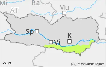
Very little snow on the ground
Avalanches hardly possible
Snowpack
Rainfall led to the snowpack becoming massively wet in all aspected over widespread areas. There is little snow on the ground.
Tendency
No significant change in avalanche danger levels expected
Danger level
Isolated danger zones occur on NW/N/NE facing slopes above 1800m
Due to fresh snow and SW winds, small snowdrift accumulations have been generated in gullies and bowls. Isolated danger zones occuron NW/N/NE facing slopes above 1800m.
Snowpack
Some snowfall is anticipated. The SW winds will transport the fresh fallen snow. Freshly generated snowdrift accumulations will be deposited on NW/N/NE facing slopes above 1800m atop soft layewrs. Below 1600m there is hardly any snow on the ground.
Tendency
No significant change in avalanche danger levels anticipated