New snow and snow drifts prone to triggering. Gliding snow can become an issue again.
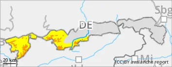
Avalanche danger above the timberline is considerable, below that altitude danger is moderat. Main problem: new snow that can trigger spontaneously as slab avalanches by a single person. Avalanche prone locations are found on steep W-N-E facing slopes adjacent to and distant from ridgelines, as well as in wind-loaded gullies and bowls. In extremely steep terrain new snow can also release naturally as loose snow avalanches in all aspects. Such avalanches can become large in rare cases. In addition, medium-sized glide snow avalanches can trigger naturally on very steep slopes with smooth ground. Be cautious esp. in sparesly wooded mountain forests and grass-covered slopes.
Snowpack
Locally up to 40 centimeters of new snow can fall by Tuesday evening. Strong southerly and westerly winds will generate fresh large-scale snowdrift accumulations. In particular on shady side slopes these are deposited atop soft layers and are prone to triggering. In some places at high altitude there are still weak layers consisting of faceted crystals close to the snowpack surface. On sunny side slopes at intermediate altitudes the new snow is deposited atop warm and partly wet bare ground, which enables gliding movements of the snowpack.
Tendency
Avalanche danger remains tense also on Wednesday.
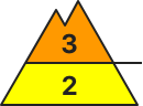
Danger level
treeline
Avalanche Problem
Wind slab
Treeline
Snowdrifts prone to triggering
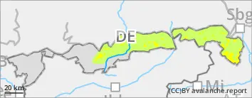
Avalanche danger above the timberline is moderate, below that altitude danger is low. Fresh snowdrift accumulations can be triggered as slab avalanches by a single person. Avalanche prone locations are found on steep W-N-E facing slopes adjacent to and distant from ridgelines, as well as in wind-loaded gullies and bowls. Releases can reach medium-size.
Snowpack
Snow line will drop slowly during Monday night. Locally up to 20 centimeters of new snow can fall by Tuesday evening. Strong southerly and westerly winds will generate fresh large-scale snowdrift accumulations. In particular on shady side slopes these are deposited atop soft layers and are prone to triggering. In some places at high altitude there are still weak layers consisting of faceted crystals close to the snowpack surface. On sunny side slopes at intermediate altitudes the new snow is deposited atop warm and partly wet bare ground, which enables gliding movements of the snowpack.
Tendency
Avalanche danger increases due to expected snowfalls.