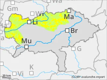
The avalanche danger above the tree line is moderate. Danger spots are especially fresh driftwood accumulations in the sectors north, east and south. Behind ridgelines as well as in the beginning of gullies and bowls slab avalanches can be triggered by small additional loads. In some places avalanches can slab through low weak layers within the old snow and reach medium sizes.
Snowpack
Fresh wind-drifted snow has formed in the eastern and southern sectors, which is not well bonded to the ground in places. Below this, a succession of crusts and softer layers will form an increasingly unstable snow layering in higher altitudes.
Tendency
The weather will remain cold and windy on Monday. The avalanche danger doesn’t change significantly.
Danger level
treeline
Avalanche Problem
Wind slab
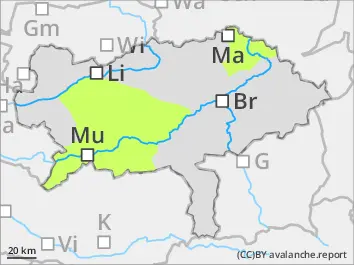
Treeline
Low avalanche danger - only isolated danger spots due to fresh snowdrift deposits.
The avalanche danger is low. Danger spots are fresh snowdrift deposits in some places. These are located in high entrances to gullies and bowls and behind terrain edges, especially in eastern and southern exposures. Small slab avalanches can be triggered here by even a low additional load.
Snowpack
In the extended eastern sector small fresh snowdrift deposits are formed in some places. At shady high altitudes and in blown-in gullies, a small unstable snow base in form of a succession of crusts and softer layers is present. At medium and lower altitudes as well as on sunny slopes, the snow base is missing.
Tendency
The weather on Monday will be cold and windy. The avalanche danger doesn’t change significantly.