Rainfall up to 1800m, wet loose-snow avalanches expected
Snowdrift accumulations which are prone to triggering will be generated particularly in gullies, bowls and behind protruberances in the landscape due to fresh snow and strong-velocity winds will increase further The freshly generated drifts can be triggered even by one sole skier. Isolated dry-snow avalanches also possible, esp. in the major areas of participation. Releases will be mostly small-sized, medium-sized in isolated cases. Size of danger zones tend to increase with ascending altitude.Shady slopes are especially unfavorable. Danger zones tend to increase in frequency with ascending altitude.
Snowpack
dp.6: cold, loose snow and wind
Up to 30 cm of fresh snow was registered regionally (Hochstuhl-Koschuta) above 1900m, locally more. During the night an additional 10cm of fresh snow is expected, locally more. The often stormy winds will transport the fresh snow and even the old snow. The varied snowdrifts are often poorly bonded with each other and with the old snowpack beneath them. They lie atop a weak old snowpack above 1900m on shadyn slopes. There is too little snow on the ground for this juncture of the season.
Tendency
Circumvent fresh snowdrift accumulations
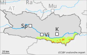
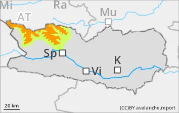
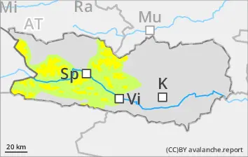
Danger level
1800m
Avalanche Problem
Wind slab
1800m
Circumvent snowdrifts
Snowdrift accumulations which are prone to triggering will be generated particularly in gullies, bowls and behind protruberances in the landscape due to fresh snow and medium-velocity winds will increase further The freshly generated drifts can be triggered even by one sole skier. Isolated dry-snow avalanches also possible, esp. in the major areas of participation. Releases will be mostly small-sized, medium-sized in isolated cases. Size of danger zones tend to increase with ascending altitude.Shady slopes are especially unfavorable. Danger zones tend to increase in frequency with ascending altitude.
Snowpack
dp.6: cold, loose snow and wind dp.1: deep persistent weak layer
Up to 20 cm of fresh snow was registered above 1800m, locally more, an additional 10cm is expected regionally during the nighttime hours. Often storm-strength winds will transport the fresh fallen snow, in some places also the old snow. The fresh snowdrift accumulations will be poorly bonded with the old snowpack, deposited atop a weak old snowpack surface particularly above 1800m. The fresh drifts lie deposited atop an old snowpack which is expansively metamorphosed, weak and faceted. The snowpack is highly diverse even over small areas. There is too little snow on the ground for this juncture of the season.
Snowdrift accumulations which are prone to triggering will be generated particularly in gullies, bowls and behind protruberances in the landscape due to fresh snow and storm-velocity winds. Snowdrifts can be triggered by one single skier. Avalanches can in isolated cases trigger naturally at the foot of rock cliffs and grow to medium size. They can also trigger in the weak layers in isolated cases and grow to medium size. Particularly unfavorable are shady slopes. Size and frequency of danger zones will tend to increase with ascending altitude.
Snowpack
dp.6: cold, loose snow and wind dp.1: deep persistent weak layer
Up to 10 cm of fresh snow is expected regionally, locally more. The often storm-strength winds will transport the fresh and also the old snow. The varied snowdrift accumulations are often poorly bonded with each other and with the old snowpack surface, they lie particularly on NW/N/SE facing slopes above 2400m atop a weak old snowpack. The fresh drifts also lie on top of weak layers. The snowpack is highly diverse even over small areas. There is too little snow on the ground for this juncture of the season.
Tendency
Circumvent fresh snowdrifts
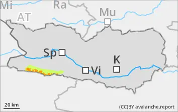
Danger level
1800m
Avalanche Problem
Wind slab
1800m
Caution: fresh snowdrift accumulations.
Due to fresh snwofall and moderate velocity winds, snowdrift accumulations which are prone to triggering will be generated particularly in gullies, bowls and behind protruberances in the landscape due to fresh snow and storm-velocity SW winds. The freshly generated drifts can be triggered even by one sole skier. Particularly unfavorable are shady slopes where there are weak layers inside the old snowpack. Releases will be mostly small-sized, medium-sized in isolated cases. Size of danger zones tend to increase with ascending altitude. Caution: be attentive to risks of being swept along and being forced to take a fall.
Snowpack
dp.6: cold, loose snow and wind
Some snowfall is expected regionally, which stormy winds will transport, including the old snow. The varied drifts are often poorly bonded with each other and with the snowpack. Drifts lie atop a weak old snowpack above 1800m on shady slopes. The snowpack is highly varied over small areas. There is too little snow on the ground for this juncture of the season.