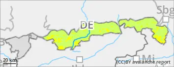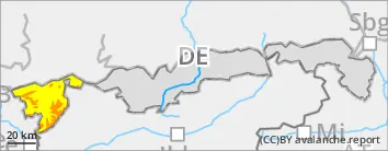
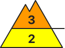
Danger level
 | treeline |
|  |
|  | ||||
|  |  |


![]()
Snowdrifts prone to triggering.
Avalanche danger above the timberline is considerable, danger below that altitude it is moderate. The main problem: snowdrifts that can be triggered as medium-sized slab avalanches even by minimum additional loading. This relates in particular to steep ridgeline terrain above the timberline in NW/E/SE aspects as well as wind-loaded gullies and bowls. However, at lower altitudes it can locally also apply to steep forest aisles. At high altitudes, avalanches can also fracture down to weak layers embedded in the old snowpack. Frequency and size of danger zones increase with ascending altitude. Isolated medium-sized glide-snow avalanches can in addition trigger naturally on smooth grass-covered slopes in all aspects.
Snowpack
During Thursday night, widespread 20cm of new snow will fall, in some places even up to 30cm which will be transported by stormy westerly winds. On the shady side, new snow and snowdrifts will be deposited atop an unfavorable expansively metamorphosed old snow surface, from place to place also on surface hoar -- easily triggerable. Weak layers can also be embedded in the snowdrifts. In particular in shady high altitude terrain layers consisting of faceted (metamorphosed) crystals are embedded in the old snowpack, which in some places are still prone to triggering. On south-facing intermediate altitude slopes, the new snow will frequently fall on bare ground. The snowpack base is moist at the ground, thus enabling gliding movements.
Tendency
Sunshine on Saturday can cause small loose snow avalanches. Avalanche danger will not change significantly.