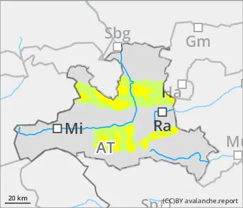
Weak old snowpack layering at high altitude is main problem
Avalanche danger levels are moderate. Avalanches can be triggered even by minimum additional loading in some places above 2200m. Danger zones occur particularly on north and east facing slopes above 2200m, on south-facing slopes above 2400m. Danger zones increase in frequency with ascending altitude and can be medium-sized. Caution urged in transitions from shallow to deep snow. Glide-snow avalanches can trigger at any time of day or night where the snow depths are sufficient, particularly blow 2400m on E/S/W facing slopes. Circumvent zones below glide cracks.
Snowpack
At night on sunny slopes and at low altitudes, a melt-freeze crust can form which then softens during the course of the day. The fresh snow has been transported far-reachingly. Exposed ridges and crests are windblown, gullies and bowls are filled to the brim even at the forest rims. The most recent snowfall has settled well. On shady slope the snowpack is still loosely-packed, was frequently able to expansively metamorphose again. Above 2200m the snowpack layering is generally unfavorable with several weak layers of faceted crystals. The entire snowpack can glide over steep rock plates or grassy slopes.
Tendency
Winds to intensify starting on Thursday, snowfall se on during Thursday night. Result: snowdrift problem will increase.
Danger level
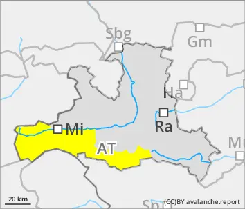
2200m
Avalanche Problem
Persistent weak layer
2200m
Weak old snowpack is main problem
Avalanche danger levels above 2200m are moderate, below that altitude danger is low. Avalanches of medium size can be triggered even by minimum additional loading in some places above 2200m, particularly on W/N/SE facing slopes and in transitions from shallow to deep snow. Danger zones increase with ascending altitude. Avalanches can reach medium size.
Snowpack
The snow on sunny slopes and at low altitudes can form a melt-freeze crust at night which then softens during the daytime. Exposed ridges and crests are windblown, gullies, bowls and slopes near forest rims are filled with snow. The transported snow has settled in the interim. On shady slopes the fresh snow is still loose, the snowpack was able to repeatedly metamorphose expansively. Above 2200m the snowpack layering is generally unfavorable, several weak layers of faceted crystals are evident. Especially on north-facing slopes the covered surface hoar is prone to triggering.
Tendency
Winds to intensify starting on Thursday, snowfall set on during Thursday night. Result: snowdrift problem will increase.
Danger level
2200m
Avalanche Problem
Persistent weak layer
2200m
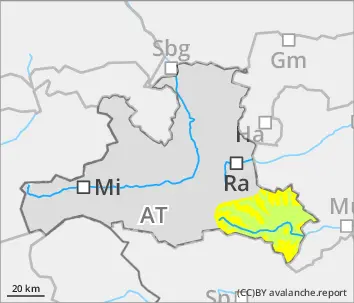
Gliding snow
2400m
Weak old snowpack layering at high altitude is main problem
Avalanche danger levels are moderate. Avalanches can be triggered even by minimum additional loading in some places above 2200m. Danger zones occur particularly on north and east facing slopes above 2200m, on south-facing slopes above 2400m. Danger zones increase in frequency with ascending altitude and can be medium-sized. Caution urged in transitions from shallow to deep snow. Glide-snow avalanches can trigger at any time of day or night where the snow depths are sufficient, particularly blow 2400m on E/S/W facing slopes. Circumvent zones below glide cracks.
Snowpack
At night on sunny slopes and at low altitudes, a melt-freeze crust can form which then softens during the course of the day. The fresh snow has been transported far-reachingly. Exposed ridges and crests are windblown, gullies and bowls are filled to the brim even at the forest rims. The most recent snowfall has settled well. On shady slope the snowpack is still loosely-packed, was frequently able to expansively metamorphose again. Above 2200m the snowpack layering is generally unfavorable with several weak layers of faceted crystals. The entire snowpack can glide over steep rock plates or grassy slopes.
Tendency
Winds to intensify starting on Thursday, snowfall set on during Thursday night. Result: snowdrift problem will increase.
Danger level
Avalanche Problem
Gliding snow
Circumvent zones below glide cracks
Avlanche danger is low, gliding snow is the main problem. On steep grass-covered slopes and over rock plates where the snow depths are sufficient, small glide-snow avalanches can trigger naturally a any time of day or night.
Snowpack
The snow on sunny slopes and at low altitudes can form a melt-freeze crust at night which then softens during the daytime. Exposed ridges and crests are windblown, gullies, bowls and slopes near forest rims are filled with snow. The fresh fallen snow has settled in the interim. On shady slopes the fresh fallen snow is still loose, the snowpack was able to metamorphose repeatedly, forming faceted crystals. The entire snowpack can start to glide over steep rock plates or grassy slopes.
Tendency
Winds to intensify starting on Thursday, snowfall set on during Thursday night. Result: snowdrift problem will increase.