Wet-snow avalanches can in isolated cases be triggered by one winter sports enthusiast and grow to medium size. These avalanche prone locations are located particularly on W/N/E-facing slopes. Rainfall is anticipated in the afternoon, thereby the likelihood of triggerings will increase.
Snowpack
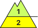
dp.10: springtime scenario
Weather conditions have led to the snowpack becoming thoroughly wet, forfeiting firmness of the snowpack. Many wet-snow avalanches have already released, many starting zones have completely discharged, the snowpack is thoroughly wet. Nocturnal outgoing longwave radiation is severely reduced, the snowpack hardly freezes, then soften rapidly in the morning hours. On steep sunny slopes below 1700m there is hardly any snow on the ground.
Tendency
Gradually receding avalanche danger
Danger level
2800m
Avalanche Problem
Wet snow
2800m
Wind slab
2800m
Main problem: wet snow
Avalanche danger below 2800m is moderate. On steep slopes below 2800m which have not yet discharged, small-to-medium sized wet avalanches can trigger naturally at any time of day or night or else be triggered by persons. Also isolated small-to-medium sized glide-snow avalanches are possible. In high-alpine zones, small dry-snow slab avalanches can be triggered by one sole skier in isolated cases, particularly on steep wind-loaded slopes and in shady gullies and bowls.
Snowpack
The snowpack is compact, moist or wet up to high altitutudes, is moist or wet already in the early morning hours, in high-alpine zones with settled, often wind-impacted snow atop a melt-freeze crust. Inside the snowpack accumulations in places are loose layers. Due to solar radiation and regional rain seepage up to high altitudes, the snowpack forfeits its firmness on steep slopes which have not yet discharged.
Tendency
Little change expected
Danger level
1800m
Avalanche Problem
Wet snow
1800m
At intermediate altitudes most avalanches have already been released.
Avalanche danger above 1800m is moderate. Wet snow can be problematic on isolated slopes with sufficient snow. Possibility of small wet loose snow avalanches in extremely steep terrain. Medium-sized glide-snow avalanches are possible on slopes over smooth ground as well as on meadows or rock slabs.
Snowpack
Up to high altitudes the snowpack is becoming increasingly wet. Barely any layering left in the snowpack. South-facing slopes are widespread bare. Above approx. 1500m there is mostly a continuous snowfield on the shady side.
Tendency
Heed wet snow at high altitudes in the next few days.
Danger level
2800m
Avalanche Problem
Wet snow
2800m
Wind slab
2800m
Beware wet-snow and snowdrifts in high-alpine terrain
Wet-snow avalanches can in isolated cases be triggered by one winter sports enthusiast and grow to medium size. These avalanche prone locations are located particularly on W/N/E-facing slopes below 2800m. Rainfall is anticipated in the afternoon, thereby the likelihood of triggerings will increase. Fresh snowdrift accumulations can be triggered by one sole skier on very steep shady slopes above 2800m. Such danger zones occur esp. in ridgeline terrain, in gullies and in bowls.
Snowpack
dp.10: springtime scenario dp.6: cold, loose snow and wind
Weather conditions below 2800m have led to the snowpack becoming thoroughly wet, forfeiting firmness of the snowpack. Many wet-snow avalanches have already released, many starting zones have completely discharged, the snowpack is thoroughly wet. Due to often strong-velocity southerly winds, snowdrift accumulations have been generated. Weather will gradually stabilize these drifts. Nocturnal outgoing longwave radiation is severely reduced, the snowpack hardly freezes, then soften rapidly in the morning hours. On steep sunny slopes below 1900m there is hardly any snow on the ground.
Tendency
No significant change expected
BEFORE NOON Danger level
1600m
Avalanche Problem
Gliding snow
1600m
AFTERNOON Danger level
1600m
Avalanche Problem
Wet snow
1600m
Caution: increasing danger in daytime cycle of avalanche danger
Avalanche danger in the morning hours is low, rises during the afternoon hours to moderate above 1600m. On steep slopes in all aspects which have not yet discharged, wet-snow avalanches can release naturally or be triggered by winter sports enthusiasts and, in high altitude zones, grow to medium size. In isolated cases small-to-medium glide-snow avalanches are possible.
Snowpack
During partially cloudy nighttime hours, reduced outgoing longwave radiation, the snowpack can freeze only superficially. With higher daytime temperatures and solar radiation the thin crust swiftly softens and the snowpack loses its firmness.
Tendency
On Thursday, instable weather conditions including precipitation. Regionally, avalanche danger can increase somewhat at high altitudes.
BEFORE NOON Danger level
2600m
Avalanche Problem
Persistent weak layer
2600m
AFTERNOON Danger level
2600m
Avalanche Problem
Wet snow
2600m
Persistent weak layer
2600m
Daytime increase of avalanche danger.
Avalanche danger is low in early morning, then rises during the afternoon above 1600m to moderate. On steep slopes below 2600m which have not yet discharged, medium-sized wet-snow avalanches can trigger naturally or be triggered by persons. Also isolated small-to-medium glide-snow avalanches are possible. In high-alpine zones, fresh snowdrift accumulations require attentiveness, most of them are small but often easily triggered. Danger zones occur in gullies, bowls, behind protruberances in the terrain and on steep shady slopes above 2600m. Isolated small-to-medium avalanches can be triggered by winter sports enthusiasts in the old snow. Avalanche prone locations lie in seldom-tracked shady terrain and are difficult to recognize.
Snowpack
During mild nights of clear skies accompanied by showers, the snowpack can freeze only slightly and in some places form a melt-freeze crust capable of bearing loads. Through higher daytime temperatures and solar radiation, the crust then softens rapidly and the snowpack loses its firmness. Especially in the Silvretta region on high-altitude very steep shady slopes there are still unfavorable intermediate layers evident inside the old snowpack.
Tendency
On Thursday, instable weather conditions including precipitation. Regionally, avalanche danger can increase somewhat at high altitudes.
Danger level
Avalanche Problem
Wet snow
Beware wet snow. Isolated danger zones.
Naturally triggered wet-snow avalanches can be triggered esp. by large additional loading, most releases are small. Danger zones occur on W/N/E-facing slopes. Some rainfall is expected, which will then increase the likelihood of triggerings somewhat.
Snowpack
dp.10: springtime scenario
Weather conditions have led to the snowpack becoming thoroughly wet. Many wet-snow avalanches have already released, many starting zones have completely discharged. Nocturnal outgoing longwave radiation hardly exists. The snowpack surface can barely freeze and softens rapidly. On steep sunny slopes and below 1800m there is hardly any snow on the ground.
Tendency
No significant change expected
Danger level
Avalanche Problem
Wet snow
Isolated danger zones for wet-snow avalanches
Avalanche danger is low. In isolated cases, small glide-snow or wet-snow avalanches can release in steep terrain which has not yet discharged or it can be triggered by persons.
Snowpack
On sunny slopes, the ground is becoming bare. What little snow there is, is moist-to-wet (0-degree isotherm) and often forms a crust capable of bearing loads after a night of clear skies. Daytime warming and solar radiation soften the crust and make it forfeit its firmness.
Tendency
Little change expected
Danger level
2000m
Avalanche Problem
Wet snow
2000m
Small spontaneous loose and wet-snow avalanches possible.
The avalanche danger is assessed as low. The few danger spots are located above 2000m in extremely steep, north-facing slopes and gullies that have not yet been unloaded. Spontaneous loose and wet-snow avalanches cannot be ruled out there.
Snowpack
The snowcover is isothermal and till high altitudes wet or moist. On southern exposed slopes the snow has almost fully retreated and the retreatment increases.
Tendency
No significant change of the avalanche danger is expected.
Danger level
Hardly any avalanche prone locations left
Avalanche danger is low. On extremely steep slopes, spontaneous releases of small wet loose snow or glide-snow avalanches cannot be ruled out.