Caution: trigger-sensitive fresh snow at high altitudes. Receding danger of wet avalanches due to reduced precipitation.
From zones which have not yet discharged, further wet loose-snow avalanches can be expected, also medium-sized releases. In addition, isolated small-to-medium wet slab avalanches are possible at the foot of rock walls. Runout zones of wet-snow avalanches should be avoided. Naturally triggered wet-snow avalanches will decrease as rainfall comes to an end. Above 1700m, fresh fallen snow and drifts are prone to triggering, one sole skier can trigger avalanches esp. in gullies and bowls in the zones which are much wind-impacted. Avalanches can in isolated cases fracture down to more deeply embedded layers of the snowpack and then lengtrhen the runout zones. Due to solar radiation, increasingly frequent loose-snow avalanches can be expected during the course of the day, mostly small-sized releases in case of extensive bright intervals.
Naturally triggered small-to-medium wet avalanches will increase as rainfall sets in. On extremely steep slopes, small-to-medium wet loose-snow avalanches can be expected. Particularly at the foot of rock walls, small-to-medium wet slab avalanches are possible. Runout zones of wet-snow avalanches should be avoided. Above 1900m: lots of fresh snow expected which will be prone to triggering, also the freshly generated snowdrift accumulations, esp. in gullies and bowls in zones with wind impact. Avalanches can in isolated cases sweep along the thoroughly wet snowpack, which then lengthens the runout zone of the plummeting snow masses.
Snowpack
dp.3: rain dp.4: cold following warm / warm following cold
Rainfall will make the snowpack thoroughly wet, esp. below 1700m. Above 1700m, 30-40cm of fresh snow has been registered. By morning, another 10-20cm is expected. The fresh fallen snow is prone to triggering. In the lowermost part of the snowpack on N/W/E-facing slopes, faceted expansively metamorphosed weak layers threaten.
Tendency
Unchanged avalanche danger levels
Danger level
treeline
Avalanche Problem
Wind slab
Treeline
Wet snow
Treeline
Snowpack
Tendency
Danger level
treeline
Avalanche Problem
Wind slab
Treeline
Persistent weak layer
2000m
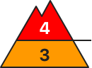
Considerable avalanche danger - the amount of danger spots is increasing due to fresh snowdrift!
The avalanche is above the treeline considerable and below that low. Snowdrift accumulations are forming danger spots which are increasing with height. They are found especially in the expositions west via east till south. They can be triggered by small additional loads as slab avalanches. In places avalanches can be triggered within the old snow in high shady areas. Spontaneous gliding- or wet loose-snow avalanches coming from steep smooth slopes are possible.
Snowpack
Fresh snowdrift accumulations are placed on top of an old snow cover with which it is often sufficiently bonded. Soft layers within the fresh cover or in shady slopes within the old snow near the surface can function as weak layers. On Sunday around 30 can new snow is called which will form - due to strong wind influence - unevenly amounts of snowdrift accumulations. In places rain respectively wetness from the ground leads to a loss of moisture within the snowcover.
Tendency
On Monday the temperatures will fall and the snowline will be around 900 m. Precipitation, predominantly in Nordstau areas are dominating. Partially stormy northern winds. Snowdrift problem is increasing due to higher amounts of new snow!
Danger level
2200m
Avalanche Problem
Persistent weak layer
2200m
Wind slab
2300m
Avoid fresh snowdrifts. Starting at midday, CONSIDERABLE danger level.
Fresh snowfall and strong-to-stormy northerly winds generated new snowdrift accumulations esp. in gullies and bowls, behind protruberances in the terrain which can be triggered in the old snow and reach medium size, particularly in wind-protected zones. Even one sole skier can trigger avalanches. Danger zones occur esp. on W/N/E-facing slopes above 2300m. Very isolated danger zones occur also on south-facing slopes above 2600m. In isolated cases, avalanches can sweep along more deeply embedded layers of the snowpack. Danger zones and likelihood of triggering will increase during the course of the day. In addition, avalanches can trigger in the near-surface layers even by one sole skier, esp. in the afternoon in the wind-impacted zones.
Snowpack
dp.6: cold, loose snow and wind
Along the Salzburg border, 20-30cm of fresh snow was registered, by morning another 10-15cm is anticipated. The often storm-strength winds will transport the snow, the freshly generated snowdrift accumulations above 2200m will be deposited atop an unfavorable old snowpack surface. Inside the old snowpack on N/W/E-facing slopes, faceted expansively metamorphosed weak layers threaten. The fresh drifts above 2300m lie deposited atop weak layers.
Tendency
Rising avalanche danger
Danger level
2000m
Avalanche Problem
Wind slab
2000m
Persistent weak layer
2200m
Gliding snow
Treeline
Daytime increase in avalanche danger due to fresh snow and wind
Avalanche danger during the morning will be moderate above 2200m, below that altitude danger is low. With increasing amounts of fresh fallen snow, avalanche danger above 2200m will rise to CONSIDERABLE. Avalanches can in some zones be triggered by one sole skier, esp. in the afternoon, and grow to medium size. Danger zones occur in the old snow on north-facing slopes above 2200m, in all aspects above 2400m. Fresh snowdrift accumulations occur both near to and distant from ridgelines, behind protruberances in the terrain, and in gullies and bowls. Particularly below 2000m the old snowpack is thoroughly wet and small-to-medium wet-snow avalanches are possible. Avalanches in high altitudes can sweep along more deeply embedded layers of the snowpack and in isolated cases plummet all the way down to the green zones. Small-to-medium glide-snow avalanches can trigger naturally in very to extremely steep grass-covered terrain.
Snowpack
By Saturday evening 30cm of fresh snow is anticipated at high altitudes. Above 2200m on north-facing slopes weak layers of faceted crystals are found in the lowermost part of the snowpack. Above 2400m on W/S/E facing slopes there are faceted crystals between crusts. Inside the snowdrifts, in addition, trigger-sensitive layers can form rapidly. Below 2000m the snowpack will forfeit its firmness on Friday night due to rainfall and water seepage.
Tendency
On Saturday night, increase in avalanche danger due to fresh snow and wind
Danger level
1800m
Avalanche Problem
Wind slab
1800m
Avalanche situation demands great caution
Fresh snowfall and strong-to-stormy northerly winds have generated trigger-sensitive snowdrift accumulations esp. in gullies, bowls, behind protruberances in the terrain, which can easily be triggered in all aspects above 1800m or else trigger naturally. Danger zones are easily recognized for the practiced eye. Due to solar radiation, increasingly frequent loose-snow avalanches can be expected during the course of the day, mostly small-sized releases.
Snowpack
dp.6: cold, loose snow and wind dp.4: cold following warm / warm following cold
Until now, 40-50cm of fresh snow has been registered above 1800m. By morning, another 10-20cm is expected. The freshly generated snowdrift accumulations lie atop unfavorable layers in all aspects above 1800m
Tendency
Avalanche danger levels will recede
BEFORE NOON Danger level
treeline
Avalanche Problem
New snow
Treeline
AFTERNOON Danger level
treeline
Avalanche Problem
Wind slab
Treeline
New snow
Treeline
New snow problem turns into snowdrift problem
Above the timberline avalanche danger rises from moderate to considerable. Below the timberline it remains low. Snowdrifts will become the main problem. During the course of the day, many trigger-prone snowdrifts will accumulate in steep ridgeline terrain in N/E/S aspects as well as in gullies and bowls and behind slope protuberances. These are triggerable as slabs by low additional loading and can reach medium size. In addition, new fallen snow can trigger as loose snow avalanches in steep rocky terrain. Such avalanches generally remain small-sized.
Snowpack
At intermediate altitude up to 30cm of new snow have fallen on previously bare ground or on encrusted, stable remnant snow. At higher altitudes the new snow was deposited atop loose snow layers, in particular in shady areas. During the course of the day, westerly winds will intensify, generating fresh snowdrifts above the timberline. These accumulate atop loose new snow and are prone to triggering. The snowpack base is wet and by and large stable.
Tendency
Due to wind and new fallen snow avalanche danger will remain tense.
Danger level
treeline
Avalanche Problem
Wind slab
Treeline
Persistent weak layer
2200m
Attention: snowdrifts prone to triggering
Due to NW winds, trigger-sensitive snowdrifts are accumulating at high altitudes. Also the near-surface weak layers are prone to triggering in steep shady little-tracked terrain. One sole skier can trigger and small-to-medium sized slab avalanche in these zones. Wind-loaded steep terrain should be evaluated with caution. Small, in isolated cases medium-sized glide-snow avalanches are still possible. Due to daytime warming and solar radiatio, increasingly frequent loose-snow avalanches can trigger naturally on sunny slopes in steep rocky terrain.
Snowpack
Since yesterday, up to 20cm of fresh snow has been registered widespread, in the Lechquellen 30cm, in Rätikon and Silvretta 25cm. The snowdrifts which were generated by northerly winds have been deposited atop soft layers and are prone to triggering. On shady slopes at high and high alpine altitudes the near-surface and often faceted intermediate layers are prone to triggering. The snowpack is thoroughly wet up to high altitudes. Gliding movements over smooth ground continue to be possible.
Tendency
On Monday, frequent and persistent snowfall, large amounts of fresh fallen snow are expected. Avalanche danger levels will continue to rise due to fresh snowdrifts at high altitudes.
Danger level
2000m
Avalanche Problem
Persistent weak layer
2000m
Wind slab
2200m
Beware fresh snowdrifts
Fresh snowfall and strong-to-stormy northerly winds will generate new snowdrift accumulations esp. in gullies and bowls, behind protruberances in the terrain which can be triggered in the old snow and reach medium size, particularly in wind-protected zones. Even one sole skier can trigger avalanches. Danger zones occur esp. on W/N/E-facing slopes above 2200m. Very isolated danger zones occur also on south-facing slopes above 2600m. In isolated cases, avalanches can sweep along more deeply embedded layers of the snowpack. Danger zones and likelihood of triggering will increase during the course of the day. In addition, avalanches can trigger in the near-surface layers even by one sole skier, esp. in the afternoon in the wind-impacted zones.
Snowpack
dp.6: cold, loose snow and wind
Above 2000m, 5-10cm of fresh snow anticipated which will be transported by stormy winds. The fresh snowdrifts above 2200m will be deposited atop an unfavorable snowpack. In the uppermost part of the snowpack on N/W/E facing slopes, faceted expansively metamorphosed weak layers threaten.
Tendency
Little change expected
Danger level
treeline
Avalanche Problem
New snow
Treeline
Gliding snow
Treeline
Snowpack
Tendency
Danger level
treeline
Avalanche Problem
Wind slab
Treeline
Circumvent fresh snowdrifts
Due to NW winds, trigger-sensitive snowdrifts are accumulating at high altitudes. Also the near-surface weak layers are prone to triggering in steep shady little-tracked terrain. One sole skier can trigger and small-to-medium sized slab avalanche in these zones. Wind-loaded steep terrain should be evaluated with caution. Small, in isolated cases medium-sized glide-snow avalanches are still possible. Due to daytime warming and solar radiatio, increasingly frequent loose-snow avalanches can trigger naturally on sunny slopes in steep rocky terrain.
Snowpack
Since yesterday there has been 20cm of fresh snow registered. Winds from northerly directions have generated fresh snowdrift accumulations which were deposited atop soft layers and are prone to triggering. The snowpack is thoroughly wet up to high altitudes. Gliding movements of the snow masse over smooth ground are still possible.
Tendency
On Monday, frequent and persistent snowfall, large amounts of fresh fallen snow are expected. Avalanche danger levels will continue to rise due to fresh snowdrifts at high altitudes
Danger level
2200m
Avalanche Problem
Persistent weak layer
2200m
Wind slab
2200m
Daytime increase in avalanche danger. In high-alpine regions: beware hidden weak layers.
Daytime warming and solar radiation lead to increasing avalanche danger during the course of the day. In early morning, danger above 2300m is moderate, below that altitude danger is low. During the daytime it rises at all altitudes to moderate. Below 2400m, increasingly frequent small-to-medium wet-snow avalanches are possible in as aspects on steep slopes. In zones which have not yet discharged, also higher up. Small-to-medium glide-snow avalanches can trigger naturally on very steep grass-covered slopes. Above 2300m in some places, dry slab avalanches can be triggered even by one sole skier. Danger zones occur in very steep terrain and on liitle-tracked NW/NE facing slopes. Releases can fracture in the old snowpack and down to more deeply embedded layers, thereby reaching medium size.
Avalanche danger is moderate. Wet-snow avalanches can be triggered by one sole skier on steep slopes in all aspects in steep sunny terrain which has not yet discharged. Small-to-medium glide-snow avalanches can trigger naturally on extremely steep grass-covered slopes. Above 2300m, dry slab avalanches can still be triggered by one sole skier. Danger zones occur on very steep, little-tracked slopes on NW/NE facing slopes. Avalanches can fracture down to more deeply embedded layers in the snowpack and reach medium size. Small freshly generated snowdrift patches are often prone to triggering, esp. on very steep shady slopes in high-alpine ridgeline terrain. Apart from the danger of being buried in snow masses, the risks of being swept along and forced to take a fall demand adequate consideration.
Snowpack
The snowpack cools at night and forms a melt-freeze crust which is usually capable of bearing loads. During the daytime the snowpack then softens and forfeits its bonding. On shady slopes at high and high-alpine altitudes there are several weak layers of facted crystals inside the old fundament. Also moist slabs can slide away on sunny slopes over the surface crusts.
Tendency
Dense clouds at night, the snowpack can hardly cool. Snowfall will set in. Avalanche danger will increase during the course of the day.
Danger level
2000m
Avalanche Problem
Wind slab
2000m
Wet loose-snow and glide-snow avalanches in very steep terrain are the main danger
Avalanche danger is low. Isolated small loose-snow naturally triggered avalanches are possible or can be triggered by one sole skier. Danger zones for small slab avalanches in the snowdrifts occur seldom on very steep north-facing slopes at high altitudes. On steep grass-covered slopes, isolated small glide-snow avalanches are possible. Apart from the danger of being buried in snow masses, the risks of being swept along and forced to take a fall demand adequate consideration.small wet loose-snow avalanches are possible in very-to-extremely steep terrain in all aspects. The gliding snow activity will increase, small-to-medium glide-snow avalanches are possible on steep grass-covered slopes. Above 2300m, only few danger zones where still small dry slab avalanches can be triggered. Apart from the danger of being buried in snow masses, the risks of being swept along and forced to take a fall demand adequate consideration.
Snowpack
The snowpack cools at night and forms a melt-freeze crust which is usually capable of bearing loads. During the daytime the snowpack then softens and forfeits its bonding. On shady slopes at high and high-alpine altitudes there are several weak layers of facted crystals inside the old fundament. At high altitudes the old snowpack fundament is poor on shady slopes but the requisite slab is lacking.
Tendency
Dense clouds at night, the snowpack can hardly cool. Snowfall will set in. Avalanche danger will increase during the course of the day.
BEFORE NOON Danger level
2000m
Avalanche Problem
New snow
2000m
AFTERNOON Danger level
treeline
Avalanche Problem
Wind slab
Treeline
New snow
2000m
Snowdrifts prone to triggering in the afternoon.
At high altitudes, avalanche danger is moderate in the morning and above the timberline in the afternoon, below it is low. New snow is problematic early in the day, and can trigger spontaneously as small loose snow avalanches in steep terrain in all aspects. As the day progresses, fresh snowdrifts will become the predominant problem. These can be triggered as slabs by minimum additional loading. Danger zones occur above the timberline in steep N/E/S facing terrain adjacent to ridgelines as well as in wind-loaded gullies and bowls and behind slope protuberances. Slab avalanches remain mostly small. On steep grass-covered slopes that have not yet discharged isolated glide-snow avalanches cannot be ruled out.
Snowpack
At intermediate altitude up to 20cm of new snow have fallen on previously bare ground or on encrusted, stable remnant snow. At higher altitudes the new snow was deposited atop loose snow layers, in particular in shady areas. During the course of the day, westerly winds will intensify, generating fresh snowdrifts above the timberline. These accumulate atop loose new snow and are prone to triggering. The snowpack base is wet and by and large stable.
Tendency
Depending on the amount of new snow and transported quantities, avalanche danger can continue to rise at the beginning of the weak.
Danger level
treeline
Avalanche Problem
Wind slab
Treeline
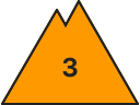
Moderate avalanche danger above the treeline - snowdrift is prone to triggering!
The avalanche is above the treeline moderate and below that low. Snowdrift accumulations are forming danger spots which are increasing with height. They are found in gullies and bowls especially in the expositions west via east till south. They can be triggered by small additional loads as slab avalanches.
Snowpack
Fresh snowdrift accumulations are placed on top of an old snow cover with which it is often sufficiently bonded or on bare soil. Soft layers within the fresh cover or in shady slopes within the old snow near the surface can function as weak layers. On Sunday around 20 cm new snow is called which will form - due to strong wind influence - unevenly amounts of snowdrift accumulations. In places rain respectively wetness from the ground leads to a loss of moisture within the snowcover.
Tendency
On Monday the temperatures will fall and the snowline will be around 900 m. Precipitation, predominantly in Nordstau areas are dominating. Partially stormy northern winds. Snowdrift problem is increasing due to higher amounts of new snow!
Danger level
1900m
Avalanche Problem
Wind slab
1900m
Avoid snowdrift accumulations
Fresh snowfall and strong-to-stormy northerly winds will generate new snowdrift accumulations esp. in gullies and bowls, behind protruberances in the terrain which can be triggered in the old snow and reach medium size, particularly in wind-protected zones. Even one sole skier can trigger avalanches. Danger zones occur esp. on W/N/E-facing slopes above 2200m. Very isolated danger zones occur also on south-facing slopes above 2600m. In isolated cases, avalanches can sweep along more deeply embedded layers of the snowpack. Danger zones and likelihood of triggering will increase during the course of the day.
Snowpack
dp.6: cold, loose snow and wind
Above 1800m, 20-30cm of fresh snow anticipated, by morning another 10-15cm of fresh fallen snow. Strong winds will transport the snow, fresh snowdrift accumulations will be deposited atop an unfavorable surface above 1900m.
Tendency
No change expected
Danger level
treeline
Avalanche Problem
Wind slab
Treeline
Gliding snow
Snowpack
Tendency
Danger level
1600m
Avalanche Problem
New snow
1600m
Now only little snow left on the ground.
Avalanche danger is low. In isolated cases the new fallen snow can be problematic and can release spontaneously as small loose snow slides/sluffs in steep rocky terrain.
Snowpack
A few centimeters of new snow have been deposited atop a patchy, encrusted and stable old snowpack. South-facing slopes are more or less bare of snow. The snow will loose firmness due to daytime warming and solar radiation. At highest altitude, westerly winds will transport the snow minimally during the course of the day. The snowpack is wet down to the ground.