Avalanches can be triggered in the old snow even by one sole skier. In addition, avalanches can be triggered even by minimum additional loading in the near-surface layers of the snowpack, esp above 2000m. Avalanches can on shady slopes sweep along the moist layers of the old snowpack and grow to large size. Caution urged at the foot of rock walls and behind protruberances in the terrain, and in gullies and bowls. Due to moistening, increasingly frequent moist loose-snow avalanches can be expected, also medium-sized ones, esp. after a night of cloudy skies on extremely steep slopes. Caution also urged towards moist slides and avalanches, also medium sized releases on extremely steep slopes after a night of cloudy skies. The runout zones should be circumvented. On very steep grass-covered slopes glide-snow avalanches are possible, also medium sized releases.
Snowpack
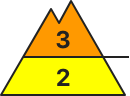
dp.7: snow-poor zones in snow-rich surrounding dp.6: cold, loose snow and wind
Since Wednesday, 80-120cm of fresh snow has been registered above 1800m, locally more. Another 5-10cm of expected above 1600m. Winds in ridgeline zones will be moderate. Fresh snow and drifts lie deposited atop soft layers, esp. above 1800m. More deeply embedded inside the snowpack on shady slopes are faceted, expansively metamorphosed weak layers, esp. above 2000m.
Tendency
Not much change expected
Danger level
2200m
Avalanche Problem
Wind slab
2200m
Persistent weak layer
2200m
Fresh snowdrifts demand route selection restraint
Avalanche danger is considerable above 2200m, below that altitude danger is low. Medium-sized slab avalanches can be triggered by one sole skier in a few steep spots. The danger zones due to fresh and older drifts lie on W/N/E facing slopes, often distant from ridgelines. Caution urged esp. at entry points into very steep gullies and bowls. During the course of the day, naturally triggered loose-snow avalanches can be expected in extremely steep south-facing terrain. On steep grass-covered slopes, isolated small glide-snow avalanches are possible in isolated cases.
Snowpack
During the course of the day, more fresh snowfall is anticipated. Transported fresh snow will be deposited on shady slopes atop soft layers, the snowpack is moistened up to high altitudes due to diffuse light conditions. Near-surface layers often form a crust due to rain seepage. The below-average old snowpack is expansively metamorphosed at high and high-alpine altitudes. Weak layers in the uppermost part of the snowpack can be triggered. On sunny slopes, melting forms dominate in the old snowpack.
Tendency
Likelihood of snowdrift accumulations triggering will gradually diminish
Danger level
1900m
Avalanche Problem
Persistent weak layer
1900m
Wet snow
Gliding snow
Unfavorable avalanche conditions
Naturally triggered dry-snow avalanches will diminish when intensive snowfall ends. Avalanches can be triggered in the old snow even by one sole skier. In addition, avalanches can be triggered even by minimum additional loading in the near-surface layers of the snowpack, esp above 1800m. Avalanches can on shady slopes sweep along the moist layers of the old snowpack and grow to large size. Caution urged at the foot of rock walls and behind protruberances in the terrain, and in gullies and bowls. Due to moistening, increasingly frequent moist loose-snow avalanches can be expected, also medium-sized ones, esp. after a night of cloudy skies on extremely steep slopes. Caution urged in gullies along the Italian and Slovenian borders. The runout zones should be circumvented. On very steep grass-covered slopes glide-snow avalanches are possible, also medium sized releases.
Snowpack
dp.1: deep persistent weak layer dp.10: springtime scenario
Since Wednesday, 80-120cm of fresh snow has been registered above 1800m, locally more. Another 15-20cm of expected above 1600m. Winds in ridgeline zones will be moderate. Fresh snow and drifts lie deposited atop soft layers, esp. above 1800m. More deeply embedded inside the snowpack on shady slopes are faceted, expansively metamorphosed weak layers, esp. above 1900m.
Tendency
No significant change expected
Danger level
Avalanche Problem
Wet snow
Persistent weak layer
2000m
Caution: snowdrift accumulations
Due to fresh snow and strong-to-storm velocity southerly winds, trigger-sensitive snowdrift accumulations have been generated esp. above 1900m on NW/N/NE facing slopes, in gullies and bowls, and behind protruberances in the terrain. Avalanches can grow to medium size, and can be triggered by winter sports enthusiasts, mostly by large additional loading.
Snowpack
dp.1: deep persistent weak layer dp.10: springtime scenario
Since Wednesday above 2000m, about 20-30 cm of fresh snow has been registered, locally more. Another 5-10cm cm of fresh snow is still expected. Winds are transporting the fresh snow. Fresh snow and drifts are being deposited on shady slopes atop an unfavorable old snowpack surface (soft layers). Weather conditions will gradually stabilie the near surface layers of the snowpack.
Tendency
No significant rise in avalanche danger
Danger level
2000m
Avalanche Problem
Persistent weak layer
2000m
Wind slab
2400m
Gliding snow
2400m
Caution: snowdrift accumulations and weak layers in the old snow
Fresh snow + moderate to strong southerly winds will generate further snowdrift accumulations, esp. on shady slopes above 2200m in gullies, bowls, behind protruberances in the terrain, which can be easily triggered or trigger naturally. Isolated danger zones occur on sunny wind-protected slopes above 2000m. In addition, avalanches can be triggered in the near-surface layers by large additional loading, these can often sweep along the thoroughly wet snowpack. Caution urged at the foot of rock walls, behind protruberances, and in gullies and bowls. Activity of small-to-medium loose-snow avalanches will increase significantly. Runout zones should be circumvented. On very steep grass-covered slopes, glide-snow avalanches are possible, also medium sized releases.
Snowpack
dp.1: deep persistent weak layer dp.7: snow-poor zones in snow-rich surrounding
Since Wednesday above 2000m, about 25-50cm of fresh snow has been registered, locally more. Above 1600m 10-15cm of fresh snow still expected. Winds will transport the fresh snow. Fresh snow and drifts are being deposited on shady slopes above 1800m atop an unfavorable old snowpack surface (soft layers). More deeply embedded inside the snowpack, esp. on shady slopes, there are expansively metamorphosed (faceted) weak layers, esp. above 2300m. Moist snowpack up to intermediate altitudes, also to some extent at higher altitudes.
Tendency
Not much change expected
Danger level
2200m
Avalanche Problem
Wind slab
2200m
Wet snow
2200m
Caution: freshly generated snowdrift accumulations at high altitudes
Fresh snow and drifts are triggerable esp. on steep shady slopes. One sole skier can trigger a small-to-medium loose-snow or slab avalanche. Apart from the danger of being buried in snow masses, the risks of being swept along and forced to take a fall require adequate caution. On steep grass-covered slopes with sufficient snow on the ground or atop smooth ground, isolated small-to-medium glide-snow avalanches are possible. In rocky terrain, slides and small loose-snow avalanches are possible.
Snowpack
The fresh snow which has fallen since Thursday has in the interim settled and increasingly consolidated at intermediate altitudes due to solar radiation. On steep slopes it is still loose and soft. Fresh snow and small drifts lie deposited on shady slopes atop expansively metamorphosed, soft layers, often blanketing graupel, bonding only moderately good. The below average snowpack is well consolidated. On sunny slopes and at lower altitudes the fresh snow will fall on bare ground.
Tendency
Starting on Tuesday, sunshine will dominate and temperatures will rise. Increasingly frequent slides and wet-snow avalanches can be expected during the course of the day.
Danger level
1800m
Avalanche Problem
New snow
1800m
Snowfall will continue
Avalanche danger is moderate above 1800 m; below that altitude it is low. Main problem: new snow. Small loose snow avalanches can trigger naturally in steep rocky terrain in all aspects. The frequency of avalanche prone locations increases with ascending altitude. In a few wind-exposed locations small slab avalanches can be triggered by a single winter sports enthusiast. Possibility of smaller glide-snow avalanches on steep slopes over smooth ground.
Snowpack
Widespread 20cm of new snow, in the Allgäu at highest altitudes in the Allgau up to half a meter of new snow, deposited atop a stable old snowpack; accompanied by fog and zero-degree temperatures a breakable crust has formed. Inside the fresh snow masses there are weak intermediate layers of graupel. At higher altitudes, ridgeline snow is bonded like a slab. The snowpack basis is wet over far-reaching areas.
Tendency
Precipitation will taper off and avalanche danger slowly recede amidst stable high-pressure front weather conditions.
Danger level
2200m
Avalanche Problem
Wind slab
2200m
Caution: assess fresh drifts carefully
Avalanche danger is considerable above 2200m, below that altitude danger is low. Medium-sized slab avalanches can be triggered by one sole skier in a few steep spots. The danger zones due to fresh and older drifts lie on W/N/E facing slopes, often distant from ridgelines. Caution urged esp. at entry points into very steep gullies and bowls. During the course of the day, naturally triggered loose-snow avalanches can be expected in extremely steep south-facing terrain. On steep grass-covered slopes, isolated small glide-snow avalanches are possible in isolated cases.
Snowpack
During the course of the day, more fresh snowfall is anticipated. Transported fresh snow will be deposited on shady slopes atop soft layers, the snowpack is moistened up to high altitudes due to diffuse light conditions. Near-surface layers often form a crust due to rain seepage. The below-average old snowpack is expansively metamorphosed at high and high-alpine altitudes. Weak layers in the uppermost part of the snowpack can be triggered. On sunny slopes, melting forms dominate in the old snowpack.
Tendency
Likelihood of snowdrift accumulations triggering will gradually diminish
Danger level
1800m
Avalanche Problem
Wind slab
1800m
Consider snowdrift in higher altitudes!
Avalanche danger above 1.800 m moderate and below 1.800 m low. The main problem is fresh snowdrift which is partially covered and hard to spot due to poor visibility. Danger spots are located in the expositions northwest via north to east. Small to medium slab avalanches can be triggered by an individuals in steep slopes. Caution behind ridgelines. Small spontaneous loose-snow avalanches coming from extremely steep terrain are possible. Gliding-snow avalanches coming from steep grassy terrain cannot be ruled out.
Snowpack
Since Thursday it had 15 to 30 cm new snow in some places even more. The southern winds drifted the new snow to the northern sectors. In high altitudes the bonding to the mostly hard stable old snow cover is partially insufficient. Soft layers in the transition area are weak layers. In extremely steep terrain the loose new snow can loose its stability and the diffuse radiation must not be underestimated. In medium altitudes the new snow landed on top of bare areas.
Tendency
On Monday cold air masses are coming to the eastern Alps with a strong northern current. Stormy weather in the mountains. Some snow showers in the north and many clouds. Better weather in the south side of the Alps. Fresh snowdrift in eastern via southern and western slopes due to winds.
Danger level
1800m
Avalanche Problem
Wind slab
1800m
Snowpack
Tendency
Danger level
Avalanche Problem
Wind slab
Snowpack
Tendency
Danger level
Danger of falling outweighs that of being buried in snow masses
Avalanche danger is low. Isolated small loose-snow naturally triggered avalanches are possible or can be triggered by one sole skier. Danger zones for small slab avalanches in the snowdrifts occur seldom on very steep N/E facing slopes at high altitudes. On steep grass-covered slopes, isolated small glide-snow avalanches are possible.
Snowpack
Atop a shallow, generally stable snowpack, which at intermediate altitudes is already 0 degrees isotherm and on sunny slopes at high altitudes has melt-freeze forms, about 10-25 of fresh snow has been registered, without much wind impact. During daytime hours, another 5-10cm of fresh snow is expected.
Tendency
Little change expected
Danger level
Snowpack
Tendency
Danger level
Avalanche Problem
New snow
Predominantly safe conditions.
Avalanche danger is low. In isolated cases, new snow can be a problem. Small loose slides/sluffs can release spontaneously in steep rocky higher altitude terrain in all aspects. At high altitudes it cannot be ruled out that a single person engaged in winter sports triggers a small slab avalanche in wind-exposed places.
Snowpack
Widespread 20cm of new snow, deposited atop a stable old snowpack; accompanied by fog and zero-degree temperatures a breakable crust has formed. Inside the fresh snow masses there are weak intermediate layers of graupel. At higher altitudes, ridgeline snow is bonded like a slab. The snowpack basis is wet over far-reaching areas.
Tendency
Avalanche danger remains low.
Danger level
Caution: small-area drifts above the timberline
Avalanche danger is low. Isolated danger zones occur esp. in ridgeline terrain, on shady steep slopes and in extremely steep terrain. One sole skier can trigger a small-to-medium loose-snow or slab avalanche. Apart from the danger of being buried in snow masses, the risks of being swept along and forced to take a fall require adequate caution. On steep grass-covered slopes with sufficient snow on the ground or atop smooth ground, isolated small-to-medium glide-snow avalanches are possible. In rocky terrain, slides and small loose-snow avalanches are possible.
Snowpack
The fresh snow which has fallen since Thursday has in the interim settled and increasingly consolidated at intermediate altitudes due to solar radiaiton. On steep slopes it is still loose and soft. Fresh snow and small drifts lie deposited on shady slopes atop expansively metamorphosed, soft layers, often blanketing graupel, bonding only moderately good. The below average snowpack is well consolidated. On sunny slopes and at lower altitudes the fresh snow will fall on bare ground.
Tendency
Starting on Tuesday, sunshine will dominate and temperatures will rise. Increasingly frequent slides and wet-snow avalanches can be expected during the course of the day.
Danger level
Avalanche Problem
Wind slab
Avalanche danger above 1.800 m moderate and below 1.800 m low. The main problem is fresh snowdrift which is partially covered and hard to spot due to poor visibility. Danger spots are located in the expositions northwest via north to east. Small to medium slab avalanches can be triggered by an individuals in steep slopes. Caution behind ridgelines. Small spontaneous loose-snow avalanches coming from extremely steep terrain are possible. Gliding-snow avalanches coming from steep grassy terrain cannot be ruled out.
Snowpack
Since Thursday it had 15 to 30 cm new snow in some places even more. The southern winds drifted the new snow to the northern sectors. In high altitudes the bonding to the mostly hard stable old snow cover is partially insufficient. Soft layers in the transition area are weak layers. In extremely steep terrain the loose new snow can loose its stability and the diffuse radiation must not be underestimated. In medium altitudes the new snow landed on top of bare areas.
Tendency
On Monday cold air masses are coming to the eastern Alps with a strong northern current. Stormy weather in the mountains. Some snow showers in the north and many clouds. Better weather in the south side of the Alps. Fresh snowdrift in eastern via southern and western slopes due to winds.