Poor visibility hinders danger assessment at high altitude
Avalanche danger is moderate. At low and intermediate altitudes, small wet loose-snow avalanches can be expected in very steep starting zones due to rain seepage. Above 2000m in some places even one person can trigger a small, in seldom occurrences medium-sized slab avalanche. Danger zones occur on W/N/E facing steep slopes, often distant from ridgelines. Caution urged especially at entry points into very steep gullies and bowls. On very steep grass-covered slopes, isolated small glide-snow avalanches are possible.
Snowpack
On shady high altitudes slopes, trigger-sensitive snowdrift accumulations lie deposited atop a faceted old snowpack surface. On sunny slopes following a night of much reduced outgoing radiation, breakable melt-freeze crusts prevail. Rain seepage is burdening the already heavily moistened snowpack.
Tendency
Following a night of overcast skies on Monday night, rapid loss of snowpack firmness on sunny slopes on Tuesday. At high altitudes persistent snowdrift problem on north-facing slopes.
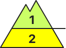
Danger level
2000m
Avalanche Problem
Wet snow
2000m
Wind slab
2000m
CAUTION: Increasing danger of moist/wet avalanches due to rainfall. Fresh drifts at high altitudes.
Due to rainfall, increasingly frequent moist/wet avalanches are possible below 2000m, esp. on very steep slopes in all aspects. Avalanches tend to be small-sized, triggerable even by one sole person. Moderate strength winds from the south: often trigger-sensitive snowdrift accumulations will be generated in ridgeline teerrain, esp. at high altitudes. Weak layers inside the old snow can be triggered in isolated cases, esp. on very steep W/N/E facing slopes and at the foot of rock wall. Avalanches can in isolated cases grow to medium size.
Snowpack
dp.3: rain dp.6: cold, loose snow and wind
Rainfall below 2000m, above that altitude up to 15cm of fresh snow is expected, locally more, esp. at high altitudes in SW regions. Winds will transport the fresh and old snow. Fresh drifts will be deposited on W/N/E facing slopes at high altitudes atop soft layers. In the lowermost part of the snowpack on W/N/E facing slopes there are faceted, expansively metamorphosed weak layers evident.
Tendency
Rising avalanche danger during the daytime due to rain, snow, wind
Danger level
2000m
Avalanche Problem
Wind slab
2000m
Wet snow
2000m
Fresh snowdrifts at high altitudes. Wet snow avalanches due to rainfall.
Avalanche danger is moderate. Due to rainfall, increasingly frequent mostly small-sized wet loose-snow avalanches can be expected below 2000m. Above 2000m small, in isolated cases also medium-sized avalanches can be triggered by winter sports enthusiasts in steep terrain. Danger zones occur esp. on steep shady ridgeline slopes. Apart from the danger of being buried in snow masses, the risks of being swept along and forced to take a fall require adequate caution. On steep grass-covered slopes with sufficient snow on the ground or atop smooth ground, increasingly frequent small-to-medium glide-snow avalanches are possible.
Snowpack
On Sunday night and during the day on Monday above 2000m, about 5cm of fresh snow is anticipated. Brisk SW winds will transport the frseh snow, also some of the loose old snow, and mostly thin snowdrift accumulations will be generated. Also on Sunday, the strong foehn winds will form small snowdrifts. Due to dense cloud cover moving in on Sunday night, the snowpack surface cannot firm up sufficiently. Below 2000-1800m, light rainfall will weaken the already moist snowpack still further.
Tendency
No significant change expected
Danger level
2400m
Avalanche Problem
Wind slab
2400m
Wet snow
2000m
Caution: weak layers in old snow and freshly generated snowdrifts.
Due to moderate-to-strong southerly winds, fresh snowdrift accumulations have been generated esp. in ridgeline terrain. The fresh drifts are small but often prone to triggering, esp. a high altitudes, releases can reach medium size, particularly on W/N/E facing slopes and at the foot of rock walls at high altitudes. Due to rainfall, isolated small wet loose-snow avalanches are possible, esp. on steep slopes in all aspects.
Snowpack
dp.6: cold, loose snow and wind dp.3: rain
Rainfall below 2000m, above that altitude up to 10cm of fresh snow is expected, locally more, esp. at high altitudes in SW regions. Winds will transport the fresh and old snow. Fresh drifts will be deposited on W/N/E facing slopes at high altitudes atop soft layers. In the lowermost part of the snowpack on W/N/E facing slopes there are faceted, expansively metamorphosed weak layers evident.
Tendency
Rising avalanche danger during the daytime due to rain, snow, wind
Danger level
1800m
Avalanche Problem
Wet snow
1800m
Wind slab
2000m
In case of rain showers, snowpack will lose its firmness
Avalanche danger below 1800m is moderate. Due to the rainfall, small wet loose-snow avalanches can be expected in very steep starting zones. Above 2000m in some places even one person can trigger a small, in seldom occurrences medium-sized slab avalanche. Danger zones occur on W/N/E facing steep slopes, often distant from ridgelines. Caution urged especially at entry points into very steep gullies and bowls. On very steep grass-covered slopes, isolated small glide-snow avalanches are possible.
Snowpack
On shady high-altitude slopes, small-area trigger-sensitive snowdrift accumulations lie deposited atop a faceted old snowpack. Elsewhere, after a night of much reduced outgoing radation, breakable melt-freeze crusts, quickly softening in case of solar radiation. Rain seepage is burdening the already heavily moistened snowpack.
Tendency
On Tuesday, after a night of often clear skies, melt-freeze crusts and firn on sunny slopes, elsewhere no change.
Danger level
2000m
Avalanche Problem
Wet snow
2000m
Fresh snowdrifts in foehn lanes. Beware daytime danger cycle.
Avalanche danger below 2000m is moderate. Due to rainfall, increasingly frequent mostly small-sized wet loose-snow avalanches can be expected below 2000m. Above 2000m small, in isolated cases also medium-sized avalanches can be triggered by winter sports enthusiasts in steep terrain. Danger zones occur esp. on steep shady ridgeline slopes. Apart from the danger of being buried in snow masses, the risks of being swept along and forced to take a fall require adequate caution. On steep grass-covered slopes with sufficient snow on the ground or atop smooth ground, increasingly frequent small-to-medium glide-snow avalanches are possible.
Snowpack
On Sunday night and during the day on Monday above 2000m, a few cm of fresh snow is anticipated. Brisk SW winds will transport the frseh snow, also some of the loose old snow, and mostly thin snowdrift accumulations will be generated. Also on Sunday, the strong foehn winds will form small snowdrifts. Due to dense cloud cover moving in on Sunday night, the snowpack surface cannot firm up sufficiently. Below 2000-1800m, light rainfall will weaken the already moist snowpack still further.
Tendency
No significant change expected
Danger level
1800m
Avalanche Problem
Wind slab
1800m
Wet snow
Snowpack
Tendency
Danger level
Avalanche Problem
Wet snow
Wind slab
2200m
In high altitudes danger spots are found in some places
Avalanche danger is in general low. In high altitudes danger spots in form of snowdrift deposits which are prone to triggering are found. There - in shady areas or adjacent to ridgelines small slab avalanches can be triggered. In extremely steep slopes on sunny areas spontaneous loose-snow avalanches can’t be ruled out. Ridgelines and summits are icy and hard. Be aware of risk of falling.
Snowpack
During the night the snow cover cools down and solidifies. During the day the snow cover gets increasingly moist and unstable. On shady slopes above 2.200 m loose snow is found in some places, and in rare cases thin snowdrift deposits which are prone to triggering have formed. The snow base is predominantly stable. The snow base, which has a very low amount considering the season is predominantly stable. Especially on sunny slopes only little amounts of snow is found even in high altitudes.
Tendency
The avalanche danger will stay low.
Danger level
2000m
Avalanche Problem
Wet snow
2000m
Snowpack
Tendency
Danger level
1800m
Avalanche Problem
Wet snow
1800m
Wind slab
2000m
Loose-snow avalanches, only isolated danger zones for slab avalanches
Avalanche danger is low. Freshly generated snowdrift accumulations can be trigger a small slab avalanche in steep terrain by one sole skie. Above 2000m esp. in the Tauern, even one person can trigger a small slab avalanche. Danger zones occur on W/N/E facing steep slopes, often distant from ridgelines. Caution urged especially at entry points into very steep gullies and bowls. On very steep grass-covered slopes, isolated small glide-snow avalanches are possible.
Snowpack
On shady high-altitude slopes in the Tauern, small-area trigger-sensitive snowdrift accumulations lie deposited atop a faceted old snowpack. Elsewhere, after a night of much reduced outgoing radation, breakable melt-freeze crusts, quickly softening in case of solar radiation. Only on north-facing slopes above 1500m is the snow still dry. Rain seepage is burdening the already heavily moistened snowpack.
Tendency
On Tuesday, after a night of often clear skies, melt-freeze crusts and firn o sunny slopes, elsewhere no change.
Danger level
2200m
Avalanche Problem
Wet snow
2200m
Wind slab
1800m
Not enough snow for winter sports anymore, in particular in the Prealps.
Avalanche danger is low. Wet snow is an issue in all aspects. Small wet loose snow avalanches can trigger naturally in extremely steep terrain at intermediate altitude. Additionally, smaller glide-snow avalanches can possibly release on steep sunny side slopes over smooth ground. Isolated fresh snowdrift patches can in addition be triggered as small slabs by minimum additional loading. Avalanche prone locations are found in steep N/E-facing ridgeline terrain above 1800m. The risks of being swept along outweigh those of being buried in snow masses.
Snowpack
Where there is still snow it is superficially encrusted on the sunny side early in the morning. At higher and high altitudes the surface snow is still dry in shady terrain. At intermediate altitude the snowpack surface will become wet in all aspects following the onset of slight precipitations. Small fresh snowdrift accumulations will be generated above 1800m as a consequence of heavy winds and some snowfall.
Tendency
No significant changes.
Danger level
Isolated danger zones
Due to rainfall, moist/wet avalanches are possible, esp. on very steep slopes in all aspects. Avalanche releases mostly small-sized. Due to moderate southerly winds, small snowdrifts are being generated in high altitude ridgeline terrain.
Snowpack
dp.3: rain dp.6: cold, loose snow and wind
Rainfall regionally up to 2000m, snowfall above that altitude. Winds will transport the fresh and old snow. Inside the snowpack on shady sloeps are faceted expansively metamorphosed weak layers.