Danger of small (where snowfall has been heavy also medium-sized) glide-snow avalanches on steep grass-covered slopes or rocky plates remains difficult to asses. Caution urged below glide cracks. Otherwise avalanche dange ris low. Isolated triggerings by winter sports enthusiasts in extremely steep terrain are possible. The danger of being swept along and forced to take a fall outweighs that of being buried in snow masses.
Snowpack
The below-average snowpack is well consolidated by and large. In high altitude pass and ridgeline zones, small fresh, often trigger-sensitive snowdrift accumulations require attentiveness. Esp. on steep shady slopes these drifts have been deposited atop loose snow and are prone to triggering. On sunny slopes the most recent snowfall is already moist and is forming a melt-freeze crust. During the daytime hours, this crust softens up again.
Tendency
Avalanche danger levels expected to remain favorable also on Sunday
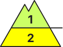
Danger level
2000m
Avalanche Problem
Wet snow
2000m
Caution: isolated cornices instable!
Avalanche danger is low. Wet snow can be problematic. Small loose-snow avalanches can triggered during the daytime hours, mostly on extremely steep slopes at intermediate altitudes. On very steep slopes with deep enough snow and a smooth ground surface, glide-snow avalanches possible.
Snowpack
In early morning the snowpack is compact, often frozen hard, and largely stable. Due to daytime warming it softens up rapidly during the day. The snowpack is then moist on the surface, forfeiting firmness, in some places it is utterly wet. On shady slopes the snow is also increasingly moist on the surface. Only at high altitudes is the loose snow still dry. Snowpack analysis and snow profiles show good snowpack stability by and large. On south-facing slopes the ground is becoming bare of snow.
Tendency
Avalanche danger levels not expected to change significantly in the next few days
Danger level
1800m
Avalanche Problem
Persistent weak layer
1800m
Snowpack
Tendency
Danger level
Avalanche danger low. The amount of snow is low.
Still low avalanche danger. Danger spots can be located in high altitudes in shady, extremely steep areas. There slab avalanches and driftsnow accumulations could be triggered.
Snowpack
In high altitudes small amounts of snowdrift accumulations have formed which partially are on top of faceted snow which can be considered as weak layers in rare cases. The snow surface got wet on Saturday, but will be hard on Sunday. Blown-off areas are hard and icy. The kinetic metamorphosis weakens the snow base on shady slopes.
Tendency
Sunday night little amount of snowfall is called tough this is irrelevant to the avalanche situation. The avalanche danger stays low.
Danger level
Snowpack
Tendency
Danger level
Snowpack
Tendency
Danger level
2200m
Avalanche Problem
Persistent weak layer
2200m
Small danger zones on extremely steep shady slopes
Avalanche danger is low. Triggering of slab avlaanches is currently possible only in few places on extremely steep slopes. Esp. on south-facing slopes, gliding snow activity is slowly increasing. Avalanches can reach medium size. Small wet loose-snow avalanches are possible in extremely steep terrain.
Snowpack
Shady slopes: on steep shady slopes above 1500m the snowpack is expansively metamorphosed. Weak layers in the lowermost part of the snowpack are no longer likely to trigger. Particjularly in the foehn lanes, shallow hardened snowdrift accumujlations disturb descents through nobby powder snow on occasion. Elsewhere the snowpack surface on north-facing slopes is often still loose. Sunny slopes: due to mild temperatures and solar radiation the snowpack surface has become wet. During the nighttime hours a melt-freeze crust can hardly form. The search for firn snow tomorrow will be challenging.
Tendency
No significant change in danger levels anticipated.
Danger level
Very isolated danger zones in gullies and bowls
Weak layers inside the old snow can be triggered in isolated cases, esp. on shady wind-protected slopes at high-altitudes. Caution urged in transitions into gullies and bowls. Danger zones occur seldom. Apart from the danger of being buried in snow masses, the risks of being swept along and forced to take a fall require adequate consideration. On very steep sunny slopes, daytime warmth and solar radiation makes mostly small wet loose-snow avalanches possible in isolated cases.
Snowpack
Shady slopes: in the middle part of the snowpack there are faceted, expansively metamorphosed weak layers, esp. on NW/N/NE facing slopes. Very steep sunny slopes: upper part of the snowpack is well consolidated, a melt-freeze crust on the surface. Sunshine and higher temperatures during the daytime moisten the snowpack. Highly varied snow depths, depending on wind impact. There is too little snow on the ground for this juncture of the season.
Tendency
Danger level
2300m
Avalanche Problem
Persistent weak layer
2300m
Caution: weak layers prone to triggering in very isolated cases. Danger zones occur seldom.
Weak layers in the old snow can be triggered in very isolated cases by one sole skier on steep W/N/E facing slopes above 2300m. Caution in transitions from shallow to deeper snow, e.g. at entry points into gullies and bowls. These danger zones occur seldom. Avalanche releases tend to be small-sized. On very steep sunny slopes, daytime warming and solar radiation make isolated small wet loose snow slides possible. The risks of being swept along and forced to take a fall outweigh those of being buried in snow masses.
Snowpack
Shady slopes: in the lowermost part of the snowpack there are faceted, expansively metamorphosed weak layers, esp. on W/N/E facing slopes. Very steep sunny slopes: the uppermost part of the snowpack is well consolidated, with a melt-freeze crust on the surface. Sunshine and higher temperatures during the daytime moisten the snowpack. Highly varied snow depths, depending on wind impact. There is too little snow on the ground for this juncture of the season.