Significant rise in avalanche danger as snowfall intensifies
Danger level 4 - “high” - will be reached above 1800m starting at midday. Due to intensive snowfall, increasingly frequent naturally triggered avalanches can be expected during the course of the day, also large-sized releaes, even by minimum additional loading. Remote triggerings are possible, particularly on steep wind-protected slopes where there has been lots of fresh snow. Also treacherous: the foot of rock walls. On extremely steep stopes, mostly small loose-snow avalanches can be expected. In isolated cases the thoroughly wet snowpack can be swept along, which lengthens the plummet zone of the release. In addition, during the afternoon in the major areas of precipitation, mostly small-sized glide-snow avalanches can release in isolated cases. Exposed sectors of transportation route can be endanged from place to place. A great deal of experience in the assessment of avalanche dangers is imperative.
Snowpack
dp.6: cold, loose snow and wind dp.3: rain
Above 1800m, 50-120cm of fresh snow is anticipated, localy more. The strong-velocity winds will transport the fresh snow intensively. On shady wind-protected slopes above 1800m: lots of fresh snow and drifts will be deposited atop an unfavorable old snowpack surface. Shady slopes where the snow is shallow above 1800m: fresh snow and drifts will be deposited atop a weak old snowpack surface. Sunny slopes above 2200m: fresh snow and drifts will be deposited atop a crust. Extremely steep grass-covered slopes below 2000m: weather conditions are bringing about a generaly increase in danger of glide-snow avalanches.
Tendency
Naturally triggered slab avalanches will decrease when the intensive snowfall comes to an end
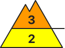
Danger level
treeline
Avalanche Problem
New snow
Treeline
Gliding snow
2000m
New snow and snow drifts prone to triggering. Gliding snow can become an issue again.
Avalanche danger above the timberline is considerable, below that altitude danger is moderat. Main problem: new snow that can trigger spontaneously as slab avalanches by a single person. Avalanche prone locations are found on steep W-N-E facing slopes adjacent to and distant from ridgelines, as well as in wind-loaded gullies and bowls. In extremely steep terrain new snow can also release naturally as loose snow avalanches in all aspects. Such avalanches can become large in rare cases. In addition, medium-sized glide snow avalanches can trigger naturally on very steep slopes with smooth ground. Be cautious esp. in sparesly wooded mountain forests and grass-covered slopes.
Snowpack
Locally up to 40 centimeters of new snow can fall by Tuesday evening. Strong southerly and westerly winds will generate fresh large-scale snowdrift accumulations. In particular on shady side slopes these are deposited atop soft layers and are prone to triggering. In some places at high altitude there are still weak layers consisting of faceted crystals close to the snowpack surface. On sunny side slopes at intermediate altitudes the new snow is deposited atop warm and partly wet bare ground, which enables gliding movements of the snowpack.
Tendency
Avalanche danger remains tense also on Wednesday.
BEFORE NOON Danger level
Avalanche Problem
Wet snow
AFTERNOON Danger level
Avalanche Problem
Wet snow
With rainfall up to 1900m, an unfavorable avalanche situation is taking shape
Due to intensive rainfall, many wet-snow avalanches can be expected during the course of the day, including medium-sized releases, particularly along the Slovenian border. The wet-snow avalanches can in steep gullies and bowls plummet down into green zones in the areas where precipitation is heaviest. It is advised to NOT partake in winter sports in steep terrain.
Snowpack
dp.3: rain
Rainfall during the course of the day will lead to the snowpack massively becoming thoroughly wet in all aspects
Tendency
Decreasing danger of wet-snow avalanches as precipiation slackens off
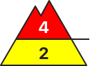
BEFORE NOON Danger level
1800m
Avalanche Problem
Persistent weak layer
1800m
AFTERNOON Danger level
1800m
Avalanche Problem
Persistent weak layer
1800m
Gliding snow
2400m
Significant rise in avalanche danger due to intensive snowfall
Due to intensive snowfall, increasingly frequent naturally triggered avalanches can be expected during the course of the day, also large sized releases, even by minimum additional loading, also remote triggerings, particularly on shady wind-protected slopes where there has been lots of fresh snow. Also treacherous: the foot of rock walls. In addition, during the afternoon in the major areas of precipitation, mostly small-sized glide-snow avalanches can release in isolated cases. Exposed sectors of transportation routes can be endanged from place to place. A great deal of experience in the assessment of avalanche dangers is imperative.
Snowpack
dp.6: cold, loose snow and wind
Above 1600m, 50-80cm of fresh snow is anticipated, localy more. On shady wind-protected slopes above 2400m: lots of fresh snow and drifts will be deposited atop an unfavorable old snowpack surface. Shady slopes where the snow is shallow above 1800m: fresh snow and drifts will be deposited atop a weak old snowpack surface. Sunny slopes above 2400m: fresh snow and drifts will be deposited atop a crust. Extremely steep grass-covered slopes below 2400m: weather conditions are bringing about a generaly increase in danger of glide-snow avalanches.
Tendency
Naturally triggered slab avalanches will decrease when the intensive snowfall comes to an end
Danger level
treeline
Avalanche Problem
New snow
Treeline
Increasing avalanche danger due to fresh snow and winds
Fresh snow and fresh snowdrift accumulations are often triggerable above the treeline on shady slopes by one sole skier and then possibly growing to medium size. Danger zones tend to increase with ascending altitude, particularly on steep shady slopes and in wind-loaded gullies and bowls. Also naturally triggered avalanches reaching medium size are possible. Activities in backcountry demand experience in avalanche danger assessment. In isolated cases, small slab avalanches can be triggered on high-altitude extremely steep shady slopes also in the old snow, usually by large additional loading and where the snow is shall
Snowpack
By Tuesday evening, 20-30 cm of fresh snow is expected widespread, locally up to 40 cm. Amid intermittently strong westerly winds, the snow will be transported and fresh snowdrifts will accumulate. Fresh snow and drifts will bond poorly-to-moderately on steep shady slopes, atop a soft old snowpack. Snowdrifts from previous days will often be blanketed. The snowpack beneath them is generally well consolidated. At lower altitudes the fresh snowfall often lies deposited on bare ground.
Tendency
Fresh snow and drifts remain prone to triggering
Danger level
1600m
Avalanche Problem
Wind slab
1600m
Southerly foehn wind is depositing snowdrifts distant from ridgelines
Avalanche danger above 1600m is considerable, below that altitude danger is low. Main danger stems from freshly generated trigger-sensitive snowdrift accumulations. Slab avalanches can be triggered by one sole skier in some places and grow to medium size, also naturally triggered avalanches are possible. Danger zones occur also distant from ridgelines, near forest rims, behind protruberances and in wind-loaded gullies and bowls on W/N/E facing slopes. As amounts of fresh snowfall increase, naturally triggered, mostly small loose-snow avalanches are likely. On shady steep slopes, fractures can in isolated cases penetrate down to more deeply embedded weak layers and the releases then grow to larger size. Caution urged in transitions from shallow to deep snow.
Snowpack
The fresh snowfall is being transported far-reachingly, deposited on shady slopes atop faceted expansively metamorphosed snowpack surfaces. In addition, blanketed fresh snow inside the masses of fresh fallen snow constitutes a weak layer. Apart from that the snowpack in wind-protected shady terrain is loosely packed. In wind-exposed terrain the snowpack surface is highly varied.
Tendency
Snowdrift accumulations remain prone to triggering
BEFORE NOON Danger level
1800m
Avalanche Problem
Wind slab
1800m
AFTERNOON Danger level
1800m
Avalanche Problem
Wind slab
1800m
Significant rise in avalanche danger as snowfall intensifies
Due to fresh snowfall and strong-velocity SW winds, widespread snowdrift accumulations will be generated during the course of the day esp. in ridgeline terrain, in gullies and bowls. These can be easily triggered in all aspects, or else trigger naturally. Avalanches will be mostly medium-sized. We advise against winter sports in steep terrain.
Snowpack
dp.6: cold, loose snow and wind
Above 1800m, 50cm of fresh snow is anticipated, localy more. Shady slopes where the snow is shallow above 1800m: fresh snow and drifts will be deposited atop a weak old snowpack surface. Sunny slopes above 2200m: fresh snow and drifts will be deposited atop a crust. Extremely steep grass-covered slopes below 2000m: weather conditions are bringing about a generaly increase in danger of glide-snow avalanches.
Tendency
Naturally triggered slab avalanches will decrease when the intensive snowfall comes to an end
Danger level
treeline
Avalanche Problem
Wind slab
Treeline
Snowdrifts prone to triggering
Avalanche danger above the timberline is moderate, below that altitude danger is low. Fresh snowdrift accumulations can be triggered as slab avalanches by a single person. Avalanche prone locations are found on steep W-N-E facing slopes adjacent to and distant from ridgelines, as well as in wind-loaded gullies and bowls. Releases can reach medium-size.
Snowpack
Snow line will drop slowly during Monday night. Locally up to 20 centimeters of new snow can fall by Tuesday evening. Strong southerly and westerly winds will generate fresh large-scale snowdrift accumulations. In particular on shady side slopes these are deposited atop soft layers and are prone to triggering. In some places at high altitude there are still weak layers consisting of faceted crystals close to the snowpack surface. On sunny side slopes at intermediate altitudes the new snow is deposited atop warm and partly wet bare ground, which enables gliding movements of the snowpack.
Tendency
Avalanche danger increases due to expected snowfalls.
Danger level
1800m
Avalanche Problem
Wind slab
1800m
Caution: fresh snowdrifts
Avalanche danger above 1800m is moderate, below that altitude danger is low. Main danger stems from fresh snowdrifts. Slab avalanches of small-to-medium size can be triggered even by minimum additional loading on steep NW/N/E facing slopes. Danger zones occur near to ridgelines, behind protruberances and in gullies and bowls. Size and frequency of danger zones tend to increase with ascending altitude and as the day unfolds.
Snowpack
Fresh snow will be transported in wind-exposed terrain. Near-surface weak layers constitute a weak layer on shady slopes, as also does the blanketed fresh snow. Where rain transforms to snowfall the bonding between fresh snow and old snowpack is good. In generally, there is below average snow on the ground.
Tendency
The freshly generated snowdrifts will slowly settle.
Danger level
treeline
Avalanche Problem
New snow
Treeline
Fresh snow and snowdrifts are prone to triggering
Fresh snow and fresh snowdrift accumulations are often triggerable above the treeline on shady slopes by one sole skier and then possibly growing to medium size. Danger zones tend to increase with ascending altitude, particularly on steep shady slopes and in wind-loaded gullies and bowls. Also naturally triggered avalanches reaching medium size are possible. In isolated cases, small slab avalanches can be triggered on high-altitude extremely steep shady slopes also in the old snow, usually by large additional loading and where the snow is shallow.
Snowpack
By Tuesday evening, 15-25 cm of fresh snow is expected widespread. Amid intermittently strong westerly winds, the snow will be transported and fresh snowdrifts will accumulate. Fresh snow and drifts will bond poorly-to-moderately on steep shady slopes, atop a soft old snowpack. Snowdrifts from previous days will often be blanketed. The snowpack beneath them is generally well consolidated. At lower altitudes the fresh snowfall often lies deposited on bare ground.
Tendency
Fresh snow and drifts remain prone to triggering
Danger level
1600m
Avalanche Problem
Wind slab
1600m
Assess snowdrifts with caution
Avalanche danger above 1600m is moderate, below that altitude danger is low. Main danger stems from fresh snowdrifts. Slab avalanches of small-to-medium size can be triggered even by minimum additional loading on steep W/N/E facing slopes. Danger zones occur near to ridgelines, behind protruberances and in gullies and bowls. Size and frequency of danger zones tend to increase with ascending altitude and as the day unfolds.
Snowpack
Fresh snow is being transported far-reachingly, deposited on shady slopes atop a faceted expansively metamorphosed snowpack surface. In addition, the blanketed fresh snow inside the masses of fresh fallen snopw constitutes a weak layer. Apart from the drifts the snowpack is loose in wind-protected zones. In wind-exposed zones the snowpack surface is highly varied.
Tendency
Snowdrift accumulations remain prone to triggering
Danger level
1600m
Avalanche Problem
Wind slab
1600m
Persistent weak layer
1800m
Moderate avalanche danger in high altitudes - caution: fresh snowdrift!
The avalanche danger is moderate above 1.600 m. Danger spots are predominantly in northwest to eastern expositions. There fresh snowdrift accumulations are formed on a weakened old snow cover. Especially in entry and peripheral areas to extrem steep gullies and bowls slave avalanches can be triggered which can reach medium sizes.
Snowpack
The snowcover is in general unusually thin considering the season. On sunny slopes the snow cover is already moist partially wet down to the ground even in high altitudes. Fresh new snow (maximum 30 cm) is drifted with the stormy winds to north and eastern expositions and is accumulating there and prone to triggering. The bonding to the old snow layer decreases with altitude. The old snow base is built by a succession of soft layers built of faceted snow crystals and melt-freeze crusts and weakened especially in shady slopes in medium and high altitudes.
Tendency
Wednesday will be sunny but the summits will be foggy. Temperatures in 2.000 m are around-4 degrees. No significant changes of the avalanche danger is expected.
Danger level
treeline
Avalanche Problem
Wind slab
Treeline
Snowpack
Tendency
Danger level
1800m
Avalanche Problem
Persistent weak layer
1800m
Little new snow - avalanche danger low.
The avalanche danger is low. Only in some places in high altitudes an extremely steep and shady gullies and bowls small slab avalanches are possible. In case of triggered avalanches risk of injuries is more likely than risk of being buried.
Snowpack
The snow cover is unusual thin for this season and southern slopes as well as exposed areas are predominatly bare. The new snow accumulates predominantly in north to eastern expositions in from of snowdrift deposits. The old snow base is mostly wet, but in steep shady gullies are soft layers built by faceted snow crystals and melt-freeze crusts which are weakened.
Tendency
Tuesday will be cloudy with snowfall down to 1.000 m. In the area of Turrach around 30 cm of new snow is expected. In the north andh east less new snow in the Triebener Tauern around 10 cm. Due to fresh snowdrift the avalanche danger rises a little bit.
Danger level
Avalanche Problem
Wet snow
Due to rainfall, isolated wet loose-snow avalanches are possible during the course of the day
Due to rainfall, isolated wet loose-snow avalanches are possible during the course of the day, mostly small releases esp. in gullies and bowls in the major areas of precipitation.
Snowpack
dp.3: rain
During the course of the day rainfall will lead widespread to the snowpack massively becoming thoroughly wet. Very little snow lies on the ground.
Tendency
Decrease in danger of wet-snow avalanches as precipitation slackens off
Danger level
1800m
Avalanche Problem
Wind slab
1800m
Caution: ridgeline snowdrift accumulations
A
Snowpack
Fresh snow will be deposited atop a compact base. Where the precipiation turns from rain to snowfall, bonding will be mostly good. Below average amounts of snow lie on the ground.