Trigger-sensitive snowdrift accumulations are threatening. The accumulations can be easily triggered even by one sole skier. Danger zones occur in wind-loaded steep terrain, in gullies and bowls, and behind protruberances in the landscape. Size and frequency of danger zones tend to increase with ascending altitude. In addition, on steep shady slopes at high altitudes and in transitions from shallow to deep snow, isolated slab avalanches can be triggered by large additional loading. In zones where there has been rain impact, slides and small wet-snow avalanches are possible. Glide-snow avalanches, mostly small, continue to be possible. Caution urged below glide cracks.
Snowpack
Fresh snow and loosely-packed older snow will be transported widespread at high altitudes. Fresh and older, covered snowdrift accumulations are prone to triggering. The old snowpack is weakened up to high altitudes, at lower altitudes the surface is often melt-freeze encrusted, often layers of graupel are blanketed. Covered deeper layers in the old snowpack are generally compact and unlikely to trigger, mostly likely in places where the snow is shallow on very steep shady slopes.
Tendency
Fresh snowdrift accumulations remain prone to trigger at high altitudes
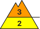
Danger level
2200m
Avalanche Problem
Persistent weak layer
2200m
Wind slab
2200m
Fresh snowdrifts and persistent weak layer at high and high-alpine altitudes
Avalanche danger above 2200m is CONSIDERABLE. Slab avalanches can trigger by minimum additional loading both in fresh (Thursday night) and older (southerly foehn-induced on Wednesday and Thursday) snowdrift accumulations near to and distant from ridgelines. The slabs are mostly small, but if fractures go down to lower layers in the snowpack the releases can grow to medium size. Most danger zones are on N/E facing slopes, higher up also on south-facing slopes. Most critical are transitions from shallow to deeper snow and at entries into gullies filled with drifts.
Snowpack
The snowpack is highly varied and still with too little snow for this juncture of the season. Crests and ridges are often windblown, gullies and bowls filled to the brim with snow. Weak layers occur as faceted crystals atop crusts and near-surface (beneath fresh snow and drifts) as well is inside the old snow.
Tendency
Wintery temperatures preserving the danger zones, avalanche risks receding only slowly
Danger level
1900m
Avalanche Problem
Wind slab
1900m
Rainfall up to 1800m, wet loose-snow avalanches expected
Snowdrift accumulations which are prone to triggering will be generated particularly in gullies, bowls and behind protruberances in the landscape due to fresh snow and strong-velocity winds will increase further The freshly generated drifts can be triggered even by one sole skier. Isolated dry-snow avalanches also possible, esp. in the major areas of participation. Releases will be mostly small-sized, medium-sized in isolated cases. Size of danger zones tend to increase with ascending altitude.Shady slopes are especially unfavorable. Danger zones tend to increase in frequency with ascending altitude.
Snowpack
dp.6: cold, loose snow and wind
Up to 30 cm of fresh snow was registered regionally (Hochstuhl-Koschuta) above 1900m, locally more. During the night an additional 10cm of fresh snow is expected, locally more. The often stormy winds will transport the fresh snow and even the old snow. The varied snowdrifts are often poorly bonded with each other and with the old snowpack beneath them. They lie atop a weak old snowpack above 1900m on shadyn slopes. There is too little snow on the ground for this juncture of the season.
Tendency
Circumvent fresh snowdrift accumulations
Danger level
1800m
Avalanche Problem
Wind slab
1800m
Gliding snow
2000m
Circumvent fresh drifts at high altitudes
Avalanche danger is moderate. Main problem: snowdrift accumulations. These can trigger a medium-sized avalanche by one sole skier/snowboarder. Avalanche prone locations occur in steep ridgeline terrain on N/E/S facing slopes and in wind-loaded gulles and bowls. At lower altitudes the slab avalanche releases are small, larger higher up. Possibility of medium-sized glide-snow avalanches on steep smooth grass-covered slopes in all aspects, releases mostly small, but occasionally medium-sized.
Snowpack
Storm-strength westerly winds will generated often trigger-sensitive snowdrift accumulations. The old snowpack at high altitudes contains layers of faceted, rounded crystals near crusts, these are prone to triggering in isolated cases on shady slopes. The old snowpack at intermediate altitudes is often thoroughl wet down to the ground, which reinforces gliding movements. In many places the fresh snow will fall on bare ground.
Tendency
On Saturday, no significant change anticipated
Danger level
1800m
Avalanche Problem
Wind slab
1800m
Circumvent snowdrifts
Snowdrift accumulations which are prone to triggering will be generated particularly in gullies, bowls and behind protruberances in the landscape due to fresh snow and medium-velocity winds will increase further The freshly generated drifts can be triggered even by one sole skier. Isolated dry-snow avalanches also possible, esp. in the major areas of participation. Releases will be mostly small-sized, medium-sized in isolated cases. Size of danger zones tend to increase with ascending altitude.Shady slopes are especially unfavorable. Danger zones tend to increase in frequency with ascending altitude.
Snowpack
dp.6: cold, loose snow and wind dp.1: deep persistent weak layer
Up to 20 cm of fresh snow was registered above 1800m, locally more, an additional 10cm is expected regionally during the nighttime hours. Often storm-strength winds will transport the fresh fallen snow, in some places also the old snow. The fresh snowdrift accumulations will be poorly bonded with the old snowpack, deposited atop a weak old snowpack surface particularly above 1800m. The fresh drifts lie deposited atop an old snowpack which is expansively metamorphosed, weak and faceted. The snowpack is highly diverse even over small areas. There is too little snow on the ground for this juncture of the season.
Tendency
Cirvumvent fresh snowdrifts
Danger level
treeline
Avalanche Problem
Wind slab
Treeline
Avalanche danger above the timberline is MODERATE. Slab avalanches, mostly small, can trigger in some steep places even by minimum additional loading on NW/E/S facing slopes both near to and distant from ridgelines, as well as in wind-loaded gullies. The danger of falling often outweighs that of being buried in snow masses. Above 2200m, isolated weak layers in the old snowpack can be triggered and avalanches can become correspondingly larger if they fracture down to more deeply embedded layers inside the snowpack. Isolated glide-snow avalanches and small wet loose-snow avalanches can trigger naturally.
Snowpack
Atop a below-average but compact and moistened snowpack in wind-protected zones, 5-20 cm of fresh snow was registered. As of 2200m there are faceted crystals more deeply embedded inside the snowpack below melt-freeze crusts. The fresh snow fell amid wind impact, thus generated new snowdrift accumulations.
Snowdrift accumulations which are prone to triggering will be generated particularly in gullies, bowls and behind protruberances in the landscape due to fresh snow and storm-velocity winds. Snowdrifts can be triggered by one single skier. Avalanches can in isolated cases trigger naturally at the foot of rock cliffs and grow to medium size. They can also trigger in the weak layers in isolated cases and grow to medium size. Particularly unfavorable are shady slopes. Size and frequency of danger zones will tend to increase with ascending altitude.
Snowpack
dp.6: cold, loose snow and wind dp.1: deep persistent weak layer
Up to 10 cm of fresh snow is expected regionally, locally more. The often storm-strength winds will transport the fresh and also the old snow. The varied snowdrift accumulations are often poorly bonded with each other and with the old snowpack surface, they lie particularly on NW/N/SE facing slopes above 2400m atop a weak old snowpack. The fresh drifts also lie on top of weak layers. The snowpack is highly diverse even over small areas. There is too little snow on the ground for this juncture of the season.
Tendency
Circumvent fresh snowdrifts
Danger level
1600m
Avalanche Problem
Wind slab
1600m
Gliding snow
Little snow on the ground, low avalanche danger
Avalanche danger levels are low. Mostly wet slides and, where snow is sufficient, small glide-snow avalanches are possible. Caution urged below glide cracks.
Snowpack
Hardly any fresh snow. At lower altitudes the shallow drifts have dissolved, the snowpack has been weakened by rain impact. Glide-snow avalanches still possible.
Tendency
No significant change expected in avalanche danger levels.
Danger level
1800m
Avalanche Problem
Wind slab
1800m
Gliding snow
2000m
Circumvent fresh drifts at high altitudes
Avalanche danger above 2000m is moderate, below that altitude danger is low. Main problem: snowdrift accumulations. These can trigger a medium-sized avalanche by one sole skier/snowboarder. Avalanche prone locations occur in steep ridgeline terrain on N/E/S facing slopes and in wind-loaded gulles and bowls. At lower altitudes the slab avalanche releases are small, larger higher up. Possibility of medium-sized glide-snow avalanches on steep smooth grass-covered slopes in all aspects, releases mostly small, but occasionally medium-sized. Possibility of medium-sized glide-snow avalanches on steep smooth grass-covered slopes in all aspects, releases mostly small, but occasionally medium-sized.
Snowpack
Storm-strength westerly winds will generate often trigger-sensitive snowdrift accumulations. The old snowpack at high altitudes contains layers of faceted, rounded crystals near crusts, these are prone to triggering in isolated cases on shady slopes. The old snowpack at intermediate altitudes is often thoroughl wet down to the ground, which reinforces gliding movemenets. In many places the fresh snow will fall on bare ground.
Tendency
On Saturday, no significant change anticipated
Danger level
treeline
Avalanche Problem
Wind slab
Treeline
Freshly generated snowdrift accumulations
Avalanche danger above the timberline is MODERATE. Slab avalanches, mostly small, can trigger in some steep places even by minimum additional loading on NW/E/S facing slopes both near to and distant from ridgelines, as well as in wind-loaded gullies. The danger of falling often outweighs that of being buried in snow masses. Above 2200m, isolated weak layers in the old snowpack can be triggered and avalanches can become correspondingly larger if they fracture down to more deeply embedded layers inside the snowpack. Isolated glide-snow avalanches and small wet loose-snow avalanches can trigger naturally.
Snowpack
Atop a below-average but compact and moistened snowpack in wind-protected zones, 5-20 cm of fresh snow was registered. As of 2200m there are faceted crystals more deeply embedded inside the snowpack below melt-freeze crusts. The fresh snow fell amid wind impact, thus generated new snowdrift accumulations.
Tendency
Wintery temperatures: avalanche danger is receding only gradually
Danger level
treeline
Avalanche Problem
Wind slab
Treeline
Persistent weak layer
Treeline
Beware of fresh wind-drifted snow at high altitudes.
The main danger spots are smaller, fresh accumulations of wind drifted snow in the north, east and south sectors. Smaller slab avalanches can be triggered behind terrain edges and in entrances to gullies and bowls by even a small additional load. In some places, avalanches can tear through weak layers of old snow close to the ground and reach medium-sized dimensions.
Snowpack
Older wind drifted snow in the northern and eastern sectors of the high altitudes is largely stable. By Friday additional smaller, fresh and partly unstable accumulations of wind drifted snow will form in the extended eastern sector. Below this, a succession of crusts and softer layers will form an increasingly unstable snow layering in the higher altitudes.
Tendency
Sunny and cold mountain weather is expected on Saturday. The avalanche danger remains unchanged.
Danger level
treeline
Avalanche Problem
Wind slab
Treeline
Persistent weak layer
Treeline
Snowpack
Tendency
Danger level
1800m
Avalanche Problem
Wind slab
1800m
Caution: fresh snowdrift accumulations.
Due to fresh snwofall and moderate velocity winds, snowdrift accumulations which are prone to triggering will be generated particularly in gullies, bowls and behind protruberances in the landscape due to fresh snow and storm-velocity SW winds. The freshly generated drifts can be triggered even by one sole skier. Particularly unfavorable are shady slopes where there are weak layers inside the old snowpack. Releases will be mostly small-sized, medium-sized in isolated cases. Size of danger zones tend to increase with ascending altitude. Caution: be attentive to risks of being swept along and being forced to take a fall.
Snowpack
dp.6: cold, loose snow and wind
Some snowfall is expected regionally, which stormy winds will transport, including the old snow. The varied drifts are often poorly bonded with each other and with the snowpack. Drifts lie atop a weak old snowpack above 1800m on shady slopes. The snowpack is highly varied over small areas. There is too little snow on the ground for this juncture of the season.
Tendency
Caution: fresh snowdrifts
Danger level
treeline
Avalanche Problem
Wind slab
Treeline
Snowpack
Tendency
Danger level
Avalanche Problem
Wind slab
Gliding snow
Low avalanche danger, little snow on the ground
Avalanche danger is low. Main problem: freshly generated snowdrift accumulations which in wind-loaded zones on N/E/S facing slopes can trigger by minimum additional loading. Slab avalanche releases are small, the risks of taking a fall are greater. In isolated cases on very steep smooth slopes, small glide-snow avalanches can trigger naturally.
Snowpack
Storm-strength westerly winds will generated often trigger-sensitive snowdrift accumulations. The old snowpack at high altitudes contains layers of faceted, rounded crystals near crusts, these are prone to triggering in isolated cases on shady slopes. The old snowpack at intermediate altitudes is often thoroughl wet down to the ground, which reinforces gliding movements. In many places the fresh snow will fall on bare ground.
Tendency
No significant change anticipated
Danger level
treeline
Avalanche Problem
Wind slab
Treeline
Low avalanche danger - only isolated danger spots due to fresh wind drifted snow.
The avalanche danger is low. Dangerous spots occur sporadically in the form of fresh snowdrift deposits. These are located in high entrances to gullies and bowls, especially in eastern exposures. Small slab avalanches can be triggered here in wind drifted snow by even a low additional load. In addition to the danger of burying, the risk of being swept away and falling should also be taken into account.
Snowpack
Older wind drifted snow in the northern and eastern sectors of the high altitudes is largely stable. By Friday, additional small snowdrift deposites will form in the extended eastern sector. At higher altitudes, a succession of crusts and softer layers will form under these snowdirft deposites, creating a somewhat unstable snow layering. At medium and lower altitudes as well as on sunny slopes, the fresh snow lies directly on the previously porous base.
Tendency
Sunny and cold mountain weather is expected on Saturday. The avalanche danger remains unchanged.