Trigger-sensitive snowdrift accumulations are forming. The accumulations can be easily triggered even by one sole skier. Danger zones occur in wind-loaded steep terrain, in gullies and bowls, and behind protruberances in the landscape. Size and frequency of danger zones tend to increase with ascending altitude. In addition, on steep shady slopes at high altitudes and in transitions from shallow to deep snow, isolated slab avalanches can be triggered by large additional loading. In zones where there has been rain impact, slides and small wet-snow avalanches are possible. Glide-snow avalanches, mostly small, continue to be possible. Caution urged below glide cracks.
Snowpack
Fresh snow and loosely-packed older snow will be transported widespread at high altitudes. Fresh and older, covered snowdrift accumulations are prone to triggering. The old snowpack is well consolidated by and large. In zones with rain impact, the snowpack is being weakened. Glide-snow avalanches continue to be possible.
Tendency
Variable conditions, fresh snowdrift accumulations remain prone to triggering
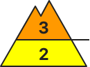
Danger level
2000m
Avalanche Problem
Wind slab
2000m
Wind slab
2000m
Persistent weak layer
2200m
Fresh snowfall to be transported widespread, trigger-sensitive snowdrifts accumulating
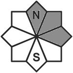
Avalanche danger above the timberline is moderate. Snowdrift accumulations above the treeline can often trigger a small-to-medium slab avalanche by one sole skier. Danger zones occur particularly in ridgelines zones and behind protruberances in the landscape. Especially in zones where snowfall has been heavy (20-30cm) the situation can be more critical. Danger zones increase quickly with ascending altitude, occur on NW/N/SE facing slopes. Trigger-sensitive snowdrift accumulations occur also distant from ridgelines, in gullies and bowls and behind protruberances in the landscape. Superficially triggered releases above 2200m can fracture down to deeper layers of the snowpack. Danger zones occur in all aspects. Caution urged in transitions from shallow to deeper snow. Due to fresh snow, gliding snow activity will slightly increase. Caution of small-to-medium glide-snow avalanches urged below 2400m and below glide cracks.
Snowpack
Up to 10-20cm of fresh snow was registered, locally more. Weak layers for slab avalanches lie inside the fresh snow and fresh drifts. On shady slopes above 2000m the old snowpack can itself be a weak layer. Above 2200m there are several weak layers of faceted crystals inside the old snow, often prone to triggering. The entire snowpack can glide over steep rocky plates or grass-covered slopes.
Tendency
At lower altitudes, proneness of snowdrifts’ triggering to slowly diminish due to higher temperatures
Danger level
1800m
Avalanche Problem
Wind slab
1800m
Wet snow
2200m
Increasing avalanche danger due to fresh snow and winds
Additional trigger-sensitive snowdrift accumulations are forming. The accumulations can be easily triggered even by one sole skier. Danger zones occur in wind-loaded steep terrain, in gullies and bowls, and behind protruberances in the landscape. Size and frequency of danger zones tend to increase with ascending altitude. In zones where there has been rain impact, slides and small wet-snow avalanches are possible. Glide-snow avalanches, mostly small, continue to be possible. Caution urged below glide cracks.
Snowpack
Trigger sensitive snowdrift accumulations will be generated. Also older accumulations can be triggered. The old snowpack is by and large well consolidated. Due to rain impact, the snowpack has been weakened. Glide-snow avalanches continue to be possible.
Tendency
Variable conditions, fresh snowdrift accumulations remain prone to triggering
Danger level
1800m
Avalanche Problem
Wind slab
1800m
Wet snow
1800m
Snowdrifts prone to triggering at high altitue
Avalanche danger 1800m is considerable, below that altitude danger is low. Main problem: snowdrift accumulations. These can trigger a medium-sized avalanche by one sole skier/snowboarder. Avalanche prone locations occur in steep ridgeline terrain on N/E/SE facing slopes and in wind-loaded gulles and bowls. Size and frequency of danger zones tend to increase with ascending altitude and during the course of the day. In addition, wet snow is a problem, it can trigger naturally on very steep slopes as a loose-snow avalanche. Possibility of medium-sized glide-snow avalanches on steep smooth grass-covered slopes in all aspects, releases mostly small, but occasionally medium-sized.
Snowpack
Dry snow is being transported by S/W winds. Inside the drifts themselves, trigger-sensitive layers are being generated. Proneness to triggering tends to increase with ascending altitude. Below the snowfall level the snowpack is superficially moist, depending on the intensity of rainfall, and it is forfeiting firmness. Weak layers inside the old snowpack have largely consolidated at high altitudes, are triggerable only in isolated cases. The snowpack base is moist-to-wet down to the ground. Gliding snow is possible.
Tendency
Danger of dry-snow avalanches persists at high altitudes
Danger level
1800m
Avalanche Problem
Wind slab
1800m
Rainfall up to 1600m, circumvent drifts above 1800m. Isolated naturally triggered avalanches still possible.
Snowdrift accumulations which are prone to triggering have been generated particularly in gullies, bowls and behind protruberances in the landscape due to fresh snow and storm-velocity SW winds. The freshly generated drifts can be triggered even by one sole skier. Particularly unfavorable are shady slopes where there are weak layers inside the old snowpack. Releases will be mostly small-sized, medium-sized in isolated cases. Size of danger zones tend to increase with ascending altitude.
Snowpack
dp.6: cold, loose snow and wind dp.1: deep persistent weak layer
Rainfall widespread up to 1600m, above 1800m up to 60 cm of fresh snow was registered, most between Hochstuhl and Koschuta. Often moderate winds transported the fresh fallen snow. The fresh snowdrift accumulations were deposited atop a weak old snowpack surface particularly on shady slopes above 1800m. Further snowdrifts will accumulate during the course of the day. The snowpack is highly diverse even over small areas. There is too little snow on the ground for this juncture of the season.
Snowdrift accumulations which are prone to triggering were generated particularly in gullies, bowls and behind protruberances in the landscape due to fresh snow and increasingly storm-velocity SW winds. Snowdrifts can be triggered by one single skier. Avalanches can in isolated cases trigger naturally and grow to medium size. They can also trigger in the weak layers in isolated cases and grow to medium size. Particularly unfavorable are shady slopes. Size and frequency of danger zones will tend to increase with ascending altitude.
Snowpack
dp.6: cold, loose snow and wind dp.1: deep persistent weak layer
Up to 25 cm of fresh snow was registered, locally more. Often moderate winds transported the fresh fallen snow. The fresh snowdrift accumulations were deposited atop a weak old snowpack surface particularly on NW/N/SE facing slopes above 2400m. The old snowpack is expansively metamorphosed, and faceted. Further snowdrifts will accumulate during the course of the day. The snowpack is highly diverse even over small areas.
Tendency
Circumvent fresh snowdrifts
Danger level
treeline
Avalanche Problem
Wind slab
Treeline
Persistent weak layer
2200m
Fresh snow being transported widespread, trigger-sensitive snowdrifts accumulating
Avalanche danger above the timberline is moderate. Snowdrift accumulations above the treeline can often trigger a small-to-medium slab avalanche by one sole skier. Danger zones occur particularly in ridgelines zones and behind protruberances in the landscape. Danger zones increase quickly with ascending altitude, occur on NW/N/SE facing slopes. Trigger-sensitive snowdrift accumulations occur also distant from ridgelines, in gullies and bowls and behind protruberances in the landscape. Superficially triggered releases above 2200m can fracture down to deeper layers of the snowpack. Danger zones occur in all aspects. Caution urged in transitions from shallow to deeper snow. Due to fresh snow, gliding snow activity will slightly increase. Caution of small-to-medium glide-snow avalanches urged below 2400m and below glide cracks.
Snowpack
Up to 10-20cm of fresh snow was registered, locally more. Weak layers for slab avalanches lie inside the fresh snow and fresh drifts. On shady slopes above 2000m the old snowpack can itself be a weak layer. Above 2200m there are several weak layers of faceted crystals inside the old snow, often prone to triggering. The entire snowpack can glide over steep rocky plates or grass-covered slopes.
Tendency
At lower altitudes, trigger-sensitivity of snowdrift accumulations to gradually decrease due to higher temperatures
Additional trigger-sensitive snowdrift accumulations can be easily triggered even by one sole skier. Danger zones occur also distant from ridgelines in wind-loaded steep terrain, in gullies and bowls, and behind protruberances in the landscape. Size and frequency of danger zones tend to increase with ascending altitude. Glide-snow avalanches, mostly small, continue to be possible. Caution urged below glide cracks.
Snowpack
Fresh snowdrift accumulations above the timberline are often prone to triggering. At lower altitudes there is little snow on the ground. Due to rain impact, the snowpack is weakening. Glide-snow avalanches are still possible.
Tendency
Variable conditions, some fresh snowfall anticipated
Danger level
1800m
Avalanche Problem
Wind slab
1800m
Circumvent snowdrifts
Snowdrift accumulations which are prone to triggering were generated particularly in gullies, bowls and behind protruberances in the landscape due to fresh snow and increasingly storm-velocity SW winds. Snowdrifts can be triggered by one single skier. Avalanches can in isolated cases trigger naturally and grow to medium size. They can also trigger in the weak layers in isolated cases and grow to medium size. Particularly unfavorable are shady slopes. Size and frequency of danger zones will tend to increase with ascending altitude.
Snowpack
dp.6: cold, loose snow and wind dp.1: deep persistent weak layer
Up to 30 cm of fresh snow was registered regionally, locally more. Often moderate winds transported the fresh fallen snow. The fresh snowdrift accumulations were deposited atop a weak old snowpack surface particularly on NW/N/SE facing slopes above 1800m. The old snowpack is expansively metamorphosed, and faceted. The snowpack is highly diverse even over small areas.
Tendency
Cirvumvent fresh snowdrifts
Danger level
treeline
Avalanche Problem
Wind slab
Treeline
Freshly generated snowdrift accumulations prone to triggering
Avalanche danger above the timberline is moderate. Snowdrift accumulations above the treeline can often trigger a small-to-medium slab avalanche by one sole skier. Danger zones occur particularly in ridgelines zones and behind protruberances in the landscape. Danger zones increase quickly with ascending altitude, occur on NW/N/SE facing slopes. Trigger-sensitive snowdrift accumulations occur also distant from ridgelines, in gullies and bowls and behind protruberances in the landscape. Superficially triggered releases above 2200m can fracture down to deeper layers of the snowpack. Danger zones occur in all aspects. Caution urged in transitions from shallow to deeper snow. Due to fresh snow, gliding snow activity will slightly increase. Caution of small-to-medium glide-snow avalanches urged below 2400m and below glide cracks.
Snowpack
Up to 10-20cm of fresh snow was registered, locally more. Weak layers for slab avalanches lie inside the fresh snow and fresh drifts. On shady slopes above 2000m the old snowpack can itself be a weak layer. Above 2200m there are several weak layers of faceted crystals inside the old snow, often prone to triggering. The entire snowpack can glide over steep rocky plates or grass-covered slopes.
Tendency
Little change expected before Wednesday
Danger level
treeline
Avalanche Problem
Wind slab
Treeline
Persistent weak layer
Treeline
Snowpack
Tendency
Danger level
treeline
Avalanche Problem
Wind slab
Treeline
Fresh trigger-sensitive snowdrifts accumulating near ridgelines
Avalanche danger above the treeline is moderate. Danger zones can release small slab avalanches by one sole skier. Danger zones occur particularly in ridgelines zones and behind protruberances in the landscape. Small-to-medium glide-snow avalanches still possible. Caution urged below glide cracks.
Snowpack
Up to 10-20cm of fresh snow was registered, locally more. Weak layers for slab avalanches lie inside the fresh snow and fresh drifts. On shady slopes above 2000m the old snowpack can itself be a weak layer. Above 2200m there are several weak layers of faceted crystals inside the old snow, often prone to triggering. The entire snowpack can glide over steep rocky plates or grass-covered slopes.
Tendency
Avalanche danger levels expected to decrease slightly
Danger level
treeline
Avalanche Problem
Persistent weak layer
Treeline
Wind slab
Treeline
-
Beware of fresh drift snow at high altitudes.
The avalanche danger is assessed as moderate above the tree line. Attention must be paid to the drift snow and persistent weak layers. The danger spots are in the north and east sectors. It cannot be completely ruled out that a snow slab can be triggered by a small additional load. In places, avalanches can tear through layers of old snow close to the ground and become medium-sized. As the weather warms up, wet loose snow slides are also possible from steep rocky and rugged terrain.
Snowpack
10 to 20cm of fresh snow has fallen in the last 24 hours. The largest amount of fresh snow was in the Totes Gebirge, with up to 20cm. Up to 10cm of fresh snow was recorded in the Niedere Tauern. The fresh snow covers hard or icy old snow surfaces. Under the hard layer, the accumulating transformation weakens the snowpack foundation. As it warms up, the new snow becomes sticky up to the middle layers. The snowpack can settle. In general, the snow cover is very unevenly distributed, with little snow from the middle layers downwards.
Tendency
It will remain mild. Thursday will start off overcast, with some snow or rain possible in the western mountain ranges. The weather will improve during the day as a strong south-westerly wind picks up and the sun will shine again and again during the day, especially to the north and east. The temperature will be around 0 degrees at an altitude of 2000m.
Danger level
1800m
Avalanche Problem
Wind slab
1800m
Rainfall up to 1600m, caution urged towards snowdrifts above 1800m
Due to fresh snwofall and moderate velocidty winds, snowdrift accumulations which are prone to triggering have been generated particularly in gullies, bowls and behind protruberances in the landscape due to fresh snow and storm-velocity SW winds. The freshly generated drifts can be triggered even by one sole skier. Particularly unfavorable are shady slopes where there are weak layers inside the old snowpack. Releases will be mostly small-sized, medium-sized in isolated cases. Size of danger zones tend to increase with ascending altitude. Caution: be attentive to risks of being swept along and being forced to take a fall.
Snowpack
dp.6: cold, loose snow and wind dp.1: deep persistent weak layer
Rainfall widespread up to 1600m, above 1800m up to 15 cm of fresh snow was registered. Often moderate winds transported the fresh fallen snow. The fresh snowdrift accumulations were deposited atop a weak old snowpack surface particularly on shady slopes above 1800m. Further snowdrifts will accumulate during the course of the day. The snowpack is highly diverse even over small areas. There is too little snow on the ground for this juncture of the season.
Tendency
Caution: fresh snowdrift accumulations
Danger level
1800m
Avalanche Problem
Wind slab
1800m
Caution: fresh snowdrift accumulations.
Due to fresh snwofall and moderate velocity winds, snowdrift accumulations which are prone to triggering have been generated particularly in gullies, bowls and behind protruberances in the landscape due to fresh snow and storm-velocity SW winds. The freshly generated drifts can be triggered even by one sole skier. Particularly unfavorable are shady slopes where there are weak layers inside the old snowpack. Releases will be mostly small-sized, medium-sized in isolated cases. Size of danger zones tend to increase with ascending altitude. Caution: be attentive to risks of being swept along and being forced to take a fall.
Snowpack
dp.6: cold, loose snow and wind
Up to 15 cm of fresh snow was registered regionally, locally more. Often moderate winds transported the fresh fallen snow. The fresh snowdrift accumulations were deposited atop a weak old snowpack surface above 1800m. on shady slopes. Further snowdrifts will accumulate during the course of the day. The snowpack is highly diverse even over small areas.
Tendency
Caution: fresh snowdrifts
Danger level
1800m
Avalanche Problem
Wind slab
1800m
Wet snow
1800m
Snowdrifts more prone to triggering at high altitudes
Avalanche danger 1800m is considerable, below that altitude danger is low. Main problem: snowdrift accumulations. These can trigger a medium-sized avalanche by one sole skier/snowboarder. Avalanche prone locations occur in steep ridgeline terrain on N/E/SE facing slopes and in wind-loaded gulles and bowls. Size and frequency of danger zones tend to increase with ascending altitude and during the course of the day. In addition, wet snow is a problem, it can trigger naturally on very steep slopes as a loose-snow avalanche on smooth grassy slopes and over rock plates. Possibility of medium-sized glide-snow avalanches on steep smooth grass-covered slopes in all aspects, releases mostly small, but occasionally medium-sized.
Snowpack
The snowpack is superficially moist, depending on the intensity of rainfall, and it is forfeiting firmness. Fresh snowdrifts are accumulating above the snowfall level. Weak layers inside the old snowpack have largely consolidated at high altitudes, are triggerable only in isolated cases. The snowpack base is moist-to-wet down to the ground. Gliding snow is possible.
Tendency
Snowdrifts consolidate due to higher temperatures. Danger of dry-snow avalanches to diminish somewhat.
Danger level
treeline
Avalanche Problem
Wind slab
Treeline
Persistent weak layer
Treeline
Snowpack
Tendency
Danger level
treeline
Avalanche Problem
New snow
Treeline
-
Low avalanche danger - fresh snow covering the meadows.
The avalanche danger is low. There are isolated danger spots. These are located in high, shady, very steep entrances to gullies and hollows. Small slab avalanches can be triggered here in drifting snow, particularly due to high additional loads. In addition to the risk of burial, the danger of being swept away and falling should also be taken into account.
Snowpack
Between 5 and 20cm of fresh snow has fallen in the last 24 hours. The largest amounts of snow (20cm) have fallen in the Wölzer Tauern, but with little wind. The fresh snow has mostly covered an icy layer at high altitudes or snowed over the green meadow again. Below the layer of fresh snow, there is still a more or less continuous snow cover only at high altitudes and on the shaded side. The old snow cover is partially weakened by angular crystals.
Tendency
Thursday will start off overcast, with a possibility of snow or rain in the western mountain ranges. The weather will improve during the day as a strong south-westerly wind picks up and the sun will shine again and again during the day, especially to the north and east. At 2000m it will be around 0 degrees at midday.
Danger level
Avalanche Problem
Wet snow
Loose-snow avalanches more possible in regions where snowfall was heavy
Avalanche danger is low. Main problem: wet snow, which can release naturally as a loose-snow avalanche or by minimum additional loading. On smooth steep grassy slopes, isolated small glide-snow avalanches can trigger naturally. In isolated cases, snowdrifts can be a problem. Isolated danger zones occur in steep terrain of the hights summit and ridgeline regions on N/E/SE facing slopes. Avalanches can trigger generally by large additional loading, releases remain mostly small-sized.
Snowpack
The snowpack is superficially moist, depending on the intensity of rainfall, and it is forfeiting firmness. Fresh snowdrifts are prone to triggering only over small areas. The snowpack layering is increasingly collapsing. The snowpack base is moist-to-wet down to the ground. Gliding snow is possible.