Critical avalanche situation widespread in backcountry
Snowpack
Tendency
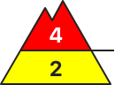
Danger level
treeline
Avalanche Problem
New snow
Treeline
Wind slab
Fresh snow and fresh drifts are prone to triggering. Increasingly frequent naturally triggered avalanches.
Snowpack
Tendency
The avalanche situation will remain critical.
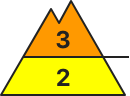
Danger level
treeline
Avalanche Problem
New snow
Treeline
Persistent weak layer
2200m
Wind slab
Critical avalanche situation widespread in backcountry
Snowpack
Tendency
BEFORE NOON Danger level
treeline
Avalanche Problem
Wind slab
Treeline
AFTERNOON Danger level
treeline
Avalanche Problem
Wind slab
Treeline
New snow
At high altitudes slab avalanches can grow to large size.
Avalanche danger above the treeline is considerable, below that altitude avalanche danger is low but will rise to moderate during the daytime. Fresh snow and drifts are problematic. Slab avalanches can be triggered even by minimum additional loading, or trigger naturally and grow to large size above the treeline. Danger zones occur near to and distant from ridgelines in steep terrain in NW/E/SW aspects. Particularly during the latter part of the day, loose-snow avalanches can trigger naturally in extremely steep terrain in all aspects and grow to large size at high altitudes. Exposed transportation routes can be placed at risk.
Snowpack
As a result of strong westerly winds, 30 to 50 cm of fresh snowfall is anticipated by Monday evening. Freshly generated trigger-sensitive snowdrift accumulations will be generated. They will be deposited atop an unfavorable old snowpack surface or atop old drifts which are themselves prone to triggering. Particularly at high altitudes there are weak layers consisting of faceted crystals located near crusts deeply embedded inside the snowpack which can be prone to triggering. The snowpack shows high impact from winds and is very irregular.
Tendency
Avalanche danger levels remain tense. Depending on the amount of snowfall intensity they could increase further by mid-week.
As a result of resh snow and increasingly stormy winds, wide-reaching snowdrift accumulations have been generated particularly in gullies and bowls and behind protruberances in the landscape. These drifts can be triggered easily by one single skier, or trigger naturally, in all aspects above 2200m. Avalanches can fracture down to more deeply embedded layers inside the snowpack on shady slopes in particular, and then grow to larger size. Whumpf noises and glide-cracks when the snowpack is tred upon are indicators of danger. Frequency and size of danger zones tend to increase with ascending altitude.
Snowpack
dp.6: cold, loose snow and wind dp.1: deep persistent weak layer
Since Friday there has been 15-20cm of fresh snow along the Salzburg border. In the afternoon, 10-15 cm of fresh snow is anticipated. Moderate winds will transporte the fresh snow. The cold fresh snow and fresh snowdrifts which lie deposited particularly in gullies, bowls and behind irregularities in the landscape, lie atop a weak old snowpack surface in all aspects above 2200m. Inside the old snowpack on shady wind-protected slopes there are faceted, expansively metamorphosed layers, particularly above 2200m. Naturally triggered and artificially triggered avalanches have brought to light the unfavorable snowpack layering. The snowpack is highly irregular over small areas.
Tendency
Circumvent snowdrift accumulations
Danger level
treeline
Avalanche Problem
Wind slab
Treeline
Persistent weak layer
2200m
Snowdrifts are the main problem. Slab avalanches in the snowdrifts can fracture in ground-level layers
Avalanche danger above the treeline is considerable, below that altitude danger is low. Avalanche danger will increase during the daytime, particularly from the west. Medium sized slab avalanches from snowdrifts can be triggered even by minimum additional loading above the greeline, particularly in gullies and bowls and behind protruberances in the landscape in all aspects. Above 2200m avalanches can be triggered from more deeply embedded layers inside the snowpack and often grow to large size. Settling noises and glide-craceks are indicators of danger. Isolated naturally triggered avalanches are possible at high altitudes. Particularly in the afternoon, snowdrift accumulations will be difficult to spot due to poor visibility.
Snowpack
Over the last 72 hours there has been 20-40 cm of fresh snow registered over widespread areas. On Monday an additional 10 cm will be added to it. The fresh snow was transported far-reachingly. Inside the fresh and older drifts there are weak near-surface layers (graupel, decomposed snow). The bonding to the old snow at low and intermediate altitudes is generally good. Above 2000m the snowdrifts often lie atop faceted crystals near crusts. On wind-protected shady slopes above the trereline there is often surface hoar. Above 2200m the snowpack layering is unfavorable, with several weak layers of faceted crystals. The entire snowpack can glide over steep rock plates or grassy slopes.
Tendency
On Tuesday avalanche danger levels will increase particularly in western regions due to fresh snowfall and wind.
Danger level
treeline
Avalanche Problem
Wind slab
Treeline
Persistent weak layer
2200m
Snowdrifts are the main problem. Slab avalanches in the snowdrifts can fracture in ground-level layers
Avalanche danger above the treeline is considerable, below that altitude danger is low. Slab avalanches of medium size can in some places be triggered from snowdrifts even by minimum additional loading, i.e. the weight of one person, especially in gullies and bowls and behind irregularities in the landscape on NW/N/SE facing slopes. In some places above 2200m they can fracture down to deeper weak layers in the old snow and thereby grow to large size. Settling noises and glide-cracks are indicators of imminent danger. Isolated naturally triggered avalanches are also possible at high altitudes. Snowdrift accumulations will be difficult to recognize in afternoon due to poor visibility.
Snowpack
Over the last 72 hours there has been 20-40 cm of fresh snow registered over widespread areas. On Monday an additional 10 cm will be added to it. The fresh snow was transported far-reachingly. Inside the fresh and older drifts there are weak near-surface layers (graupel, decomposed snow). The bonding to the old snow at low and intermediate altitudes is generally good. Above 2000m the snowdrifts often lie atop faceted crystals near crusts. On wind-protected shady slopes above the trereline there is often surface hoar. Above 2200m the snowpack layering is unfavorable, with several weak layers of faceted crystals. The entire snowpack can glide over steep rock plates or grassy slopes.
Tendency
On Tuesday avalanche danger levels will increase particularly in western regions due to fresh snowfall and wind.
Danger level
treeline
Avalanche Problem
Wind slab
Treeline
New snow
At high altitudes slab avalanches can grow to large size.
Avalanche danger above the treeline is considerable, below that altitude avalanche danger is low. The main problem: fresh and older snowdrifts. In some places, slab avalanches can be triggered even by minimum additional loading; at high altitudes, isolated slabs can be large. Avalanche prone locations are found adjacent to and distant from ridges in steep terrain in NW/W/SW aspects as well as in wind-loaded gullies and bowls and tend to increase in frequency and size with ascending altitude. Particularly during the latter part of the day, small, loose-snow avalanches can trigger naturally in extremely steep terrain.
Snowpack
As a result of strong westerly winds, 10 to 30 cm of fresh snowfall is anticipated by Monday evening. Freshly generated trigger-sensitive snowdrift accumulations will be generated. They will be deposited atop an unfavorable old snowpack surface or atop old drifts which are themselves prone to triggering. Particularly at high altitudes there are weak layers consisting of faceted crystals located near crusts deeply embedded inside the snowpack which can be prone to triggering. The snowpack shows high impact from winds and is very irregular.
Tendency
Avalanche danger levels remain tense. Depending on the amount of snowfall intensity they could increase further by mid-week.
Danger level
1600m
Avalanche Problem
Wind slab
1600m
Fresh snowdrift!
Moderate avalanche danger above 1.600 m. Wind slab problem! The new snow and the snowdrift covers danger spots. The danger spots are located in the sectors north to southeast. In the beginning of gullies and bowls an individual person can trigger a medium slab avalanch.
Snowpack
20 cm new snow has fallen between Dachstein and Totes Gebirge, a little less than that in the northern Niedere Tauern and Hochschwab. The new snow and the drift snow accumulated above the tree line on a cold soft base. The wind drifted it from the ridgelines. The soft layers within the driftsnow layer and snowy in surface hoar can be weak layers.
Tendency
Christmas will be cloudy in the mountains. Dachstein, Schladminger Tauern and Hochschwab will be permanently snowy, in the northwest heavy snow. These southern regions stay predominantly dry apart from some little snow showers. Most precipitation is expected on Nordstau! Increasing avalanche danger is to expect!
Danger level
treeline
Avalanche Problem
Wind slab
Treeline
Snowpack
Tendency
Danger level
1800m
Avalanche Problem
Wind slab
1800m
Evaluate snowdrift accumulations on shady slopes with great caution
Due to fresh snowfall and increasily stormy winds, far-reaching snowdrift accumulations are being generated, particularly on shady slopes above 1800m: easily triggered or triggering naturally. Gullies and bowls are unfavorable, since weak layers are evident inside the old snow. Avalanches are sometimes medium-sized. Apart from the risk of being buried in snow masses, you also need to take the dangers of being swept along and forced to take a fall into consideration on extremely steep slopes.
Snowpack
dp.1: deep persistent weak layer
Above 1800m the snowdrift accumulations cover a weak old snowpack on shady slopes. The old snowpack is often expansively metamorphoses, with faceted crystals. The snowpack is highly irregular even over small areas.
Tendency
Avalanche danger levels are not expected to change significantly.
Danger level
treeline
Avalanche Problem
Wind slab
Treeline
As a result of high winds and some fresh snowfall, freshly-generated trigger-sensitive snowdrift accumulations will form
Avalanche danger above the treeline is moderate, below that altitude avalanche danger is low. Main problem: snowdrifts. In some places, slab avalanches can be triggered even by minimum additional loading and can be medium-sized. Avalanche prone locations are found adjacent to and distant from ridges in steep terrain in NW/E/SW aspects and tend to increase in size and frequency with ascending altitude.
Snowpack
As a result of strong westerly winds, 10 to 20 cm of fresh snowfall is anticipated by Monday evening. Freshly generated trigger-sensitive snowdrift accumulations will be generated. They will be deposited atop an unfavorable old snowpack surface or atop old drifts which are themselves prone to triggering. The snowpack shows high impact from winds and is very irregular.
Tendency
As a result of fresh snowfall, avalanche danger levels will increase on Tuesday.
Avalanche danger levels above the treeline are moderate, below that altitude danger is low. Snowdrifts of medium size can be triggered even by minimum additional loading above the treeline, particularly near to ridgelines on NW/N/SE facing slopes. Avalanche danger levels will increase during the daytime, particularly from the west. Above 2200m avalanches can trigger in more deeply embedded weak layers inside the snowpack and in isolated cases grow to large size. Especially in the afternoon, snowdrifts can be difficult to recognize due to poor visibility.
Snowpack
The fresh fallen snow has been heftily transported. Inside the fresh snow, short-lived weak layers are forming near the surface (graupel, decomposed snow). At low and intermediate altitudes the bonding is good. Above 2000m the fresh snow and drifts have often been deposited atop faceted crystals near crusts, in some places surface hoar has been blanketed on shady, wind-protected slopes above the treeline. On wind-protected shady slopes above the treeline there is often surface hoar. Above the treeline there is surface hoar evident. Above 2200m the snowpack layering is unfavorable, there are several weak layers of faceted crystals. The entire snowpack can glide away over steep rock places or grass-covered slopes.
Tendency
On Tuesday avalanche danger levels will increase due to fresh snowfall and wind.
Danger level
1600m
Avalanche Problem
Wind slab
1600m
Snowpack
Tendency
Danger level
Avalanche Problem
Wind slab
New snow and snowdrift in high altitudes!
Low avalanche danger. A little more danger spots formed due to snowdrift. These are located in gullies and bowls above 1.600 m mainly in the sector east. Slab avalanches can be triggered by high additional loads.
Snowpack
In the southern mountains and in northeast Styria the snow base is still thin. The new snow landed on surface hoar - on the sunny side on grass. The snow base is thin and shows no significant weak layers. Blown off areas are hard and icy.
Tendency
The avalanche danger is slightly increasing in the southern Niedere Tauern. South of Mur-Mürzfurche no significant change of the avalanche danger.
Danger level
1800m
Avalanche Problem
Wind slab
1800m
Evaluate freshly generated snowdrift accumulations on shady slopes with great caution.
Over the last few days, most shallow snowdrifts have accumulated in gullies and bowls. These can be triggered by large additional loading in isolated cases above 1800m, the releases will be small sized.
Snowpack
dp.6: cold, loose snow and wind
Above 1800m the snowdrift accumulations cover a weak old snowpack on shady slopes. The old snowpack is often expansively metamorphoses, with faceted crystals. The snowpack is highly irregular even over small areas.
Tendency
Avalanche danger levels are not expected to change significantly.